Chualar elevation
Chualar (California, Monterey County), United States elevation is 36 meters and Chualar elevation in feet is 118 ft above sea level [src 1]. Chualar is a populated place (feature code) with elevation that is 243 meters (797 ft) smaller than average city elevation in United States.
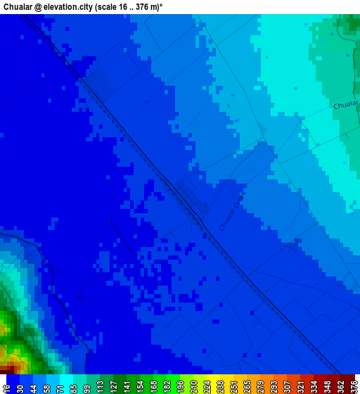
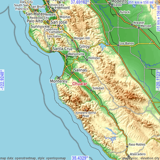
Below is the Elevation map of Chualar, which displays elevation range with different colors. Scale of the first map is from 16 to 376 m (52 to 1234 ft) with average elevation of 45.5 meters (=149 ft) [note 1]
These maps also provides idea of topography and contour of this city, they are displayed at different zoom levels. More info about maps, scale and edge coordinates you can find below images.
| \ | Map #1 | Topo.Map |
| Scale [m] | 16..376 m | × |
| Scale [ft] | 52..1234 ft | × |
| Average | 45.5 m = 149 ft | × |
| Width | 7.85 km = 4.9 mi | 251.1 km = 156 mi |
| Height | 7.85 km = 4.9 mi | 251.1 km = 156 mi |
| ↑Max Latitude | 36.605805° | 37.69162° |
| Latitude at center | 36.57052° | 36.57052° |
| ↓Min Latitude | 36.535218° | 35.4329° |
| ← Min Longitude | -121.562495° | -122.9248° |
| Longitude center | -121.51855° | -121.51855° |
| →Max Longitude | -121.474605° | -120.1123° |
Nearby cities:
Cities around Chualar sort by population:
• Salinas elevation 17 m
17.1 km,  314°
314°
• Seaside 3 m
30.1 km,  278°
278°
• Soledad 57 m
23.6 km,  133°
133°
• Marina 6 m
28.3 km,  296°
296°
• Prunedale 25 m
26.5 km,  329°
329°
• Gonzales 44 m
9.7 km,  136°
136°
• Castroville 4 m
30.5 km,  315°
315°
• Carmel Valley Village 57 m
23.2 km,  252°
252°
• Ridgemark 147 m
30.2 km,  26°
26°
• San Juan Bautista 63 m
30.6 km,  356°
356°
• Boronda 15 m
20 km, 315°
• Del Rey Oaks 19 m
28.4 km, 275°
Multilingual:
 En español:
Chualar elevación 36 m.
 En France:
Chualar élévation 36 m.


Sources and notes:
- [note 1] Map square and city borders are not equal. Map elevation data is calculated only from area inside that square.
- [src 1] Elevation data from geonames database provided with same terms of usage.
- [src 2] The elevation map of Chualar is generated using elevation data from NASA's 3 arcsec (90m) resolution SRTM data.
- [src 3] Base (background) map © OpenStreetMap contributors tiles are generated by Geofabrik and OpenTopoMap.
Copyright & License:
This Chualar Elevation Map is licensed under CC BY-SA. You may reuse any part from this page, if you give a proper credit by linking to this URL:
 More info on terms of use page.