Calimesa elevation
Calimesa (California, Riverside County), United States elevation is 732 meters and Calimesa elevation in feet is 2402 ft above sea level [src 1]. Calimesa is a populated place (feature code) with elevation that is 453 meters (1486 ft) bigger than average city elevation in United States.
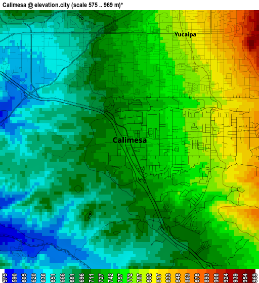
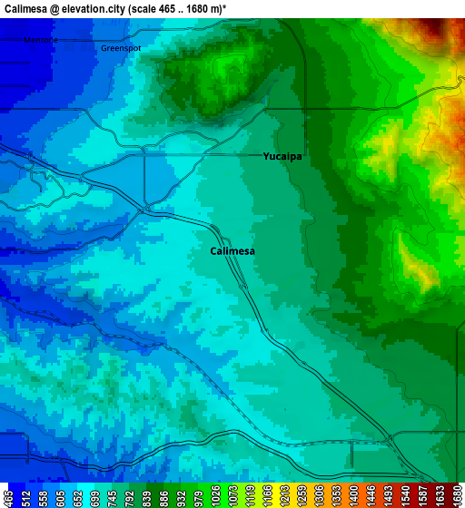
Below is the Elevation map of Calimesa, which displays elevation range with different colors. Scale of the first map is from 575 to 969 m (1886 to 3179 ft) with average elevation of 719.6 meters (=2361 ft) [note 1]
These maps also provides idea of topography and contour of this city, they are displayed at different zoom levels. More info about maps, scale and edge coordinates you can find below images.
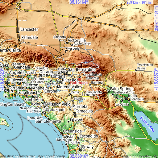
| \ | Map #1 | Map #2 | Topo.Map |
| Scale [m] | 575..969 m | 465..1680 m | × |
| Scale [ft] | 1886..3179 ft | 1526..5512 ft | × |
| Average | 719.6 m = 2361 ft | 759.9 m = 2493 ft | × |
| Width | 8.1 km = 5 mi | 16.2 km = 10.1 mi | 259.2 km = 161.1 mi |
| Height | 8.1 km = 5 mi | 16.2 km = 10.1 mi | 259.2 km = 161.1 mi |
| ↑Max Latitude | 34.040323° | 34.07673° | 35.16164° |
| Latitude at center | 34.0039° | 34.0039° | 34.0039° |
| ↓Min Latitude | 33.967462° | 33.931007° | 32.83016° |
| ← Min Longitude | -117.105925° | -117.149871° | -118.46823° |
| Longitude center | -117.06198° | -117.06198° | -117.06198° |
| →Max Longitude | -117.018035° | -116.974089° | -115.65573° |
Nearby cities:
Cities around Calimesa sort by population:
• Moreno Valley elevation 499 m
17.2 km,  244°
244°
• Redlands 417 m
12.5 km,  297°
297°
• Highland 403 m
19.3 km,  315°
315°
• Yucaipa 799 m
3.7 km,  27°
27°
• Beaumont 797 m
11.4 km,  136°
136°
• Banning 715 m
19.2 km,  116°
116°
• Loma Linda 355 m
19 km,  285°
285°
• Mentone 504 m
9.9 km, 317°
• Cherry Valley 862 m
8.6 km,  114°
114°
• Running Springs 1866 m
23.1 km,  349°
349°
• Lakeview 446 m
19.1 km,  195°
195°
• March Air Force Base 469 m
22.3 km, 236°
Multilingual:
 En español:
Calimesa elevación 732 m.
 En France:
Calimesa élévation 732 m.
 Auf Deutsch:
Calimesa höhe über dem Meeresspiegel ist 732 m.

Sources and notes:
- [note 1] Map square and city borders are not equal. Map elevation data is calculated only from area inside that square.
- [src 1] Elevation data from geonames database provided with same terms of usage.
- [src 2] The elevation map of Calimesa is generated using elevation data from NASA's 3 arcsec (90m) resolution SRTM data.
- [src 3] Base (background) map © OpenStreetMap contributors tiles are generated by Geofabrik and OpenTopoMap.
Copyright & License:
This Calimesa Elevation Map is licensed under CC BY-SA. You may reuse any part from this page, if you give a proper credit by linking to this URL:
 More info on terms of use page.