Moreno Valley elevation
Moreno Valley (California, Riverside County), United States elevation is 499 meters and Moreno Valley elevation in feet is 1637 ft above sea level [src 1]. Moreno Valley is a populated place (feature code) with elevation that is 220 meters (722 ft) bigger than average city elevation in United States.
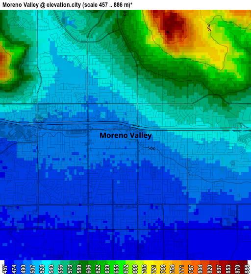
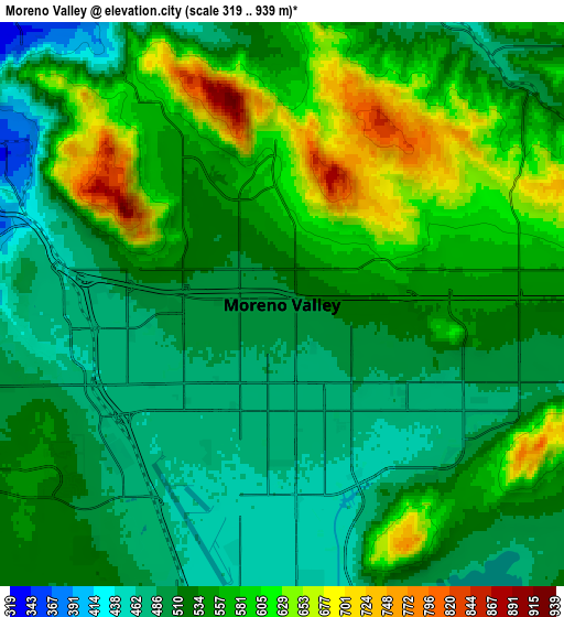
Below is the Elevation map of Moreno Valley, which displays elevation range with different colors. Scale of the first map is from 457 to 886 m (1499 to 2907 ft) with average elevation of 534.3 meters (=1753 ft) [note 1]
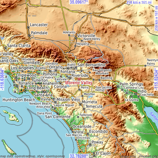
These maps also provides idea of topography and contour of this city, they are displayed at different zoom levels. More info about maps, scale and edge coordinates you can find below images.
| \ | Map #1 | Map #2 | Topo.Map |
| Scale [m] | 457..886 m | 319..939 m | × |
| Scale [ft] | 1499..2907 ft | 1047..3081 ft | × |
| Average | 534.3 m = 1753 ft | 542.3 m = 1779 ft | × |
| Width | 8.11 km = 5 mi | 16.22 km = 10.1 mi | 259.4 km = 161.2 mi |
| Height | 8.11 km = 5 mi | 16.22 km = 10.1 mi | 259.4 km = 161.2 mi |
| ↑Max Latitude | 33.973971° | 34.010407° | 35.09617° |
| Latitude at center | 33.93752° | 33.93752° | 33.93752° |
| ↓Min Latitude | 33.901053° | 33.864571° | 32.76288° |
| ← Min Longitude | -117.274535° | -117.318481° | -118.63684° |
| Longitude center | -117.23059° | -117.23059° | -117.23059° |
| →Max Longitude | -117.186645° | -117.142699° | -115.82434° |
Nearby cities:
Cities around Moreno Valley sort by population:
• Riverside elevation 257 m
15.4 km,  276°
276°
• Redlands 417 m
13.9 km,  18°
18°
• Colton 309 m
17 km,  333°
333°
• Loma Linda 355 m
12.6 km,  347°
347°
• Mead Valley 507 m
13.1 km,  207°
207°
• Woodcrest 470 m
13.2 km,  242°
242°
• Grand Terrace 322 m
13.2 km,  324°
324°
• Mentone 504 m
17.2 km,  31°
31°
• Nuevo 456 m
17 km,  152°
152°
• Highgrove 291 m
12.9 km,  312°
312°
• Lakeview 446 m
15.1 km,  136°
136°
• March Air Force Base 469 m
5.9 km, 210°
Multilingual:
 En español:
Moreno Valley elevación 499 m.
 En France:
Moreno Valley élévation 499 m.
 Auf Deutsch:
Moreno Valley höhe über dem Meeresspiegel ist 499 m.

Sources and notes:
- [note 1] Map square and city borders are not equal. Map elevation data is calculated only from area inside that square.
- [src 1] Elevation data from geonames database provided with same terms of usage.
- [src 2] The elevation map of Moreno Valley is generated using elevation data from NASA's 3 arcsec (90m) resolution SRTM data.
- [src 3] Base (background) map © OpenStreetMap contributors tiles are generated by Geofabrik and OpenTopoMap.
Copyright & License:
This Moreno Valley Elevation Map is licensed under CC BY-SA. You may reuse any part from this page, if you give a proper credit by linking to this URL:
 More info on terms of use page.