Calabasas elevation
Calabasas (California, Los Angeles County), United States elevation is 288 meters and Calabasas elevation in feet is 945 ft above sea level [src 1]. Calabasas is a section of populated place (feature code) with elevation that is 9 meters (30 ft) bigger than average city elevation in United States.
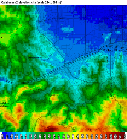
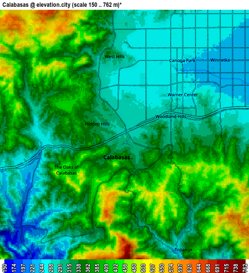
Below is the Elevation map of Calabasas, which displays elevation range with different colors. Scale of the first map is from 244 to 584 m (801 to 1916 ft) with average elevation of 345 meters (=1132 ft) [note 1]
These maps also provides idea of topography and contour of this city, they are displayed at different zoom levels. More info about maps, scale and edge coordinates you can find below images.
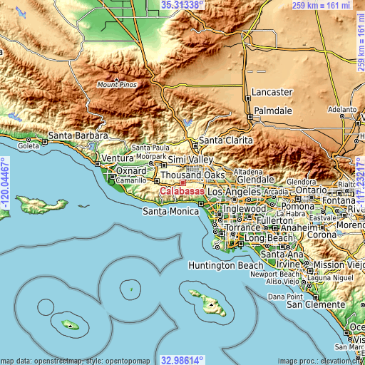
| \ | Map #1 | Map #2 | Topo.Map |
| Scale [m] | 244..584 m | 150..762 m | × |
| Scale [ft] | 801..1916 ft | 492..2500 ft | × |
| Average | 345 m = 1132 ft | 347.9 m = 1141 ft | × |
| Width | 8.09 km = 5 mi | 16.17 km = 10 mi | 258.8 km = 160.8 mi |
| Height | 8.09 km = 5 mi | 16.17 km = 10 mi | 258.8 km = 160.8 mi |
| ↑Max Latitude | 34.194137° | 34.230478° | 35.31338° |
| Latitude at center | 34.15778° | 34.15778° | 34.15778° |
| ↓Min Latitude | 34.121408° | 34.08502° | 32.98614° |
| ← Min Longitude | -118.682365° | -118.726311° | -120.04467° |
| Longitude center | -118.63842° | -118.63842° | -118.63842° |
| →Max Longitude | -118.594475° | -118.550529° | -117.23217° |
Nearby cities:
Cities around Calabasas sort by population:
• Woodland Hills elevation 277 m
3.2 km,  68°
68°
• Northridge 248 m
12.2 km,  50°
50°
• Canoga Park 245 m
6.1 km,  37°
37°
• Encino 245 m
12.6 km,  89°
89°
• West Hills 273 m
4.4 km,  353°
353°
• Chatsworth 301 m
11.6 km,  17°
17°
• Agoura Hills 504 m
12.7 km,  259°
259°
• Agoura 283 m
9.3 km, 259°
• Oak Park 335 m
11.7 km,  281°
281°
• Topanga 255 m
7.9 km,  154°
154°
• Las Flores 24 m
13.4 km,  179°
179°
• Hidden Hills 323 m
1.3 km, 282°
Multilingual:
 En español:
Calabasas elevación 288 m.
 En France:
Calabasas élévation 288 m.
 Auf Deutsch:
Calabasas höhe über dem Meeresspiegel ist 288 m.

Sources and notes:
- [note 1] Map square and city borders are not equal. Map elevation data is calculated only from area inside that square.
- [src 1] Elevation data from geonames database provided with same terms of usage.
- [src 2] The elevation map of Calabasas is generated using elevation data from NASA's 3 arcsec (90m) resolution SRTM data.
- [src 3] Base (background) map © OpenStreetMap contributors tiles are generated by Geofabrik and OpenTopoMap.
Copyright & License:
This Calabasas Elevation Map is licensed under CC BY-SA. You may reuse any part from this page, if you give a proper credit by linking to this URL:
 More info on terms of use page.