Barstow elevation
Barstow (California, San Bernardino County), United States elevation is 666 meters and Barstow elevation in feet is 2185 ft above sea level [src 1]. Barstow is a populated place (feature code) with elevation that is 387 meters (1270 ft) bigger than average city elevation in United States.
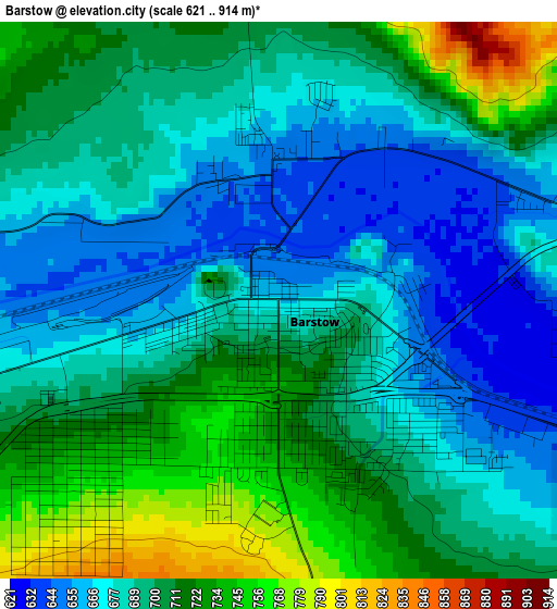
Below is the Elevation map of Barstow, which displays elevation range with different colors. Scale of the first map is from 621 to 914 m (2037 to 2999 ft) with average elevation of 696.4 meters (=2285 ft) [note 1]
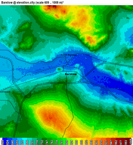
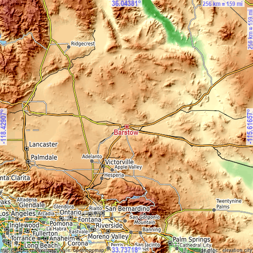
These maps also provides idea of topography and contour of this city, they are displayed at different zoom levels. More info about maps, scale and edge coordinates you can find below images.
| \ | Map #1 | Map #2 | Topo.Map |
| Scale [m] | 621..914 m | 609..1008 m | × |
| Scale [ft] | 2037..2999 ft | 1998..3307 ft | × |
| Average | 696.4 m = 2285 ft | 733.6 m = 2407 ft | × |
| Width | 8.02 km = 5 mi | 16.03 km = 10 mi | 256.5 km = 159.4 mi |
| Height | 8.02 km = 5 mi | 16.03 km = 10 mi | 256.5 km = 159.4 mi |
| ↑Max Latitude | 34.934625° | 34.970643° | 36.04381° |
| Latitude at center | 34.89859° | 34.89859° | 34.89859° |
| ↓Min Latitude | 34.86254° | 34.826473° | 33.73718° |
| ← Min Longitude | -117.066765° | -117.110711° | -118.42907° |
| Longitude center | -117.02282° | -117.02282° | -117.02282° |
| →Max Longitude | -116.978875° | -116.934929° | -115.61657° |
Nearby cities:
Cities around Barstow sort by population:
• Victorville elevation 834 m
47.2 km,  211°
211°
• Hesperia 967 m
58.3 km, 205°
• Apple Valley 902 m
46.7 km,  198°
198°
• Adelanto 881 m
49.8 km,  225°
225°
• Barstow Heights 780 m
4.4 km,  223°
223°
• Fort Irwin 762 m
50.9 km,  37°
37°
• Spring Valley Lake 851 m
50.3 km, 206°
• Lucerne Valley 898 m
50.8 km,  174°
174°
• Silver Lakes 754 m
33.7 km,  239°
239°
• Lenwood 698 m
7.8 km,  251°
251°
• Mountain View Acres 935 m
53.7 km, 213°
• Boron 756 m
58.2 km,  281°
281°
Multilingual:
 En español:
Barstow elevación 666 m.
 En France:
Barstow élévation 666 m.


Sources and notes:
- [note 1] Map square and city borders are not equal. Map elevation data is calculated only from area inside that square.
- [src 1] Elevation data from geonames database provided with same terms of usage.
- [src 2] The elevation map of Barstow is generated using elevation data from NASA's 3 arcsec (90m) resolution SRTM data.
- [src 3] Base (background) map © OpenStreetMap contributors tiles are generated by Geofabrik and OpenTopoMap.
Copyright & License:
This Barstow Elevation Map is licensed under CC BY-SA. You may reuse any part from this page, if you give a proper credit by linking to this URL:
 More info on terms of use page.