Anza elevation
Anza (California, Riverside County), United States elevation is 1195 meters and Anza elevation in feet is 3921 ft above sea level [src 1]. Anza is a populated place (feature code) with elevation that is 916 meters (3005 ft) bigger than average city elevation in United States.
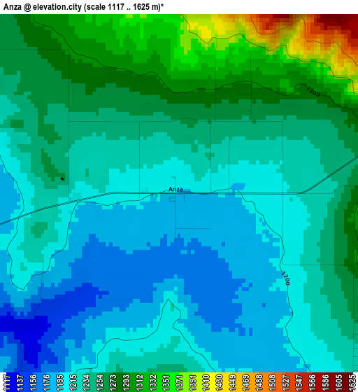
Below is the Elevation map of Anza, which displays elevation range with different colors. Scale of the first map is from 1117 to 1625 m (3665 to 5331 ft) with average elevation of 1239.6 meters (=4067 ft) [note 1]
These maps also provides idea of topography and contour of this city, they are displayed at different zoom levels. More info about maps, scale and edge coordinates you can find below images.
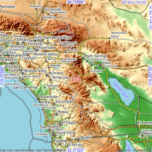
| \ | Map #1 | Topo.Map |
| Scale [m] | 1117..1625 m | × |
| Scale [ft] | 3665..5331 ft | × |
| Average | 1239.6 m = 4067 ft | × |
| Width | 8.14 km = 5.1 mi | 260.6 km = 161.9 mi |
| Height | 8.14 km = 5.1 mi | 260.6 km = 161.9 mi |
| ↑Max Latitude | 33.591644° | 34.71894° |
| Latitude at center | 33.55503° | 33.55503° |
| ↓Min Latitude | 33.5184° | 32.37522° |
| ← Min Longitude | -116.717575° | -118.07988° |
| Longitude center | -116.67363° | -116.67363° |
| →Max Longitude | -116.629685° | -115.26738° |
Nearby cities:
Cities around Anza sort by population:
• Hemet elevation 487 m
35 km,  307°
307°
• Cathedral City 100 m
31.6 km,  37°
37°
• Palm Desert 66 m
33.2 km,  55°
55°
• Palm Springs 148 m
32.8 km,  21°
21°
• La Quinta 41 m
35.8 km,  70°
70°
• Rancho Mirage 80 m
31.7 km,  49°
49°
• East Hemet 518 m
32 km, 309°
• Valle Vista 541 m
29.5 km,  316°
316°
• Indian Wells 52 m
35.6 km, 59°
• Idyllwild-Pine Cove 1661 m
21.6 km,  347°
347°
• Idyllwild 1613 m
21 km, 348°
• Aguanga 592 m
21.7 km,  234°
234°
Multilingual:
 En español:
Anza elevación 1195 m.
 En France:
Anza élévation 1195 m.


Sources and notes:
- [note 1] Map square and city borders are not equal. Map elevation data is calculated only from area inside that square.
- [src 1] Elevation data from geonames database provided with same terms of usage.
- [src 2] The elevation map of Anza is generated using elevation data from NASA's 3 arcsec (90m) resolution SRTM data.
- [src 3] Base (background) map © OpenStreetMap contributors tiles are generated by Geofabrik and OpenTopoMap.
Copyright & License:
This Anza Elevation Map is licensed under CC BY-SA. You may reuse any part from this page, if you give a proper credit by linking to this URL:
 More info on terms of use page.