La Quinta elevation
La Quinta (California, Riverside County), United States elevation is 41 meters and La Quinta elevation in feet is 135 ft above sea level [src 1]. La Quinta is a populated place (feature code) with elevation that is 238 meters (781 ft) smaller than average city elevation in United States.
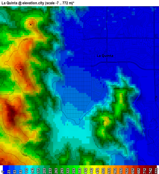
Below is the Elevation map of La Quinta, which displays elevation range with different colors. Scale of the first map is from -7 to 772 m (-23 to 2533 ft) with average elevation of 182.3 meters (=598 ft) [note 1]
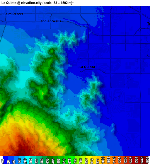
These maps also provides idea of topography and contour of this city, they are displayed at different zoom levels. More info about maps, scale and edge coordinates you can find below images.
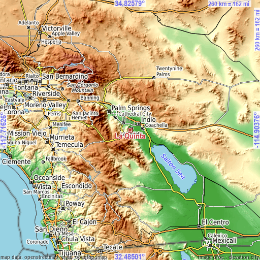
| \ | Map #1 | Map #2 | Topo.Map |
| Scale [m] | -7..772 m | -33..1502 m | × |
| Scale [ft] | -23..2533 ft | -108..4928 ft | × |
| Average | 182.3 m = 598 ft | 225.1 m = 739 ft | × |
| Width | 8.13 km = 5.1 mi | 16.27 km = 10.1 mi | 260.3 km = 161.7 mi |
| Height | 8.13 km = 5.1 mi | 16.27 km = 10.1 mi | 260.3 km = 161.7 mi |
| ↑Max Latitude | 33.699928° | 33.736481° | 34.82579° |
| Latitude at center | 33.66336° | 33.66336° | 33.66336° |
| ↓Min Latitude | 33.626776° | 33.590177° | 32.48501° |
| ← Min Longitude | -116.353955° | -116.397901° | -117.71626° |
| Longitude center | -116.31001° | -116.31001° | -116.31001° |
| →Max Longitude | -116.266065° | -116.222119° | -114.90376° |
Nearby cities:
Cities around La Quinta sort by population:
• Indio elevation -3 m
10.7 km,  53°
53°
• Cathedral City 100 m
19.3 km,  312°
312°
• Palm Desert 66 m
9 km,  316°
316°
• Coachella -21 m
12.7 km,  81°
81°
• Rancho Mirage 80 m
12.7 km, 311°
• Mecca -58 m
23.7 km,  115°
115°
• Thousand Palms 75 m
18.9 km,  336°
336°
• Bermuda Dunes 29 m
9 km,  12°
12°
• Indian Wells 52 m
6.8 km,  333°
333°
• Vista Santa Rosa -23 m
9.4 km,  114°
114°
• Thermal -37 m
16 km,  99°
99°
• Sky Valley 321 m
25.5 km,  351°
351°
Multilingual:
 En español:
La Quinta elevación 41 m.
 En France:
La Quinta élévation 41 m.
 Auf Deutsch:
La Quinta höhe über dem Meeresspiegel ist 41 m.

Sources and notes:
- [note 1] Map square and city borders are not equal. Map elevation data is calculated only from area inside that square.
- [src 1] Elevation data from geonames database provided with same terms of usage.
- [src 2] The elevation map of La Quinta is generated using elevation data from NASA's 3 arcsec (90m) resolution SRTM data.
- [src 3] Base (background) map © OpenStreetMap contributors tiles are generated by Geofabrik and OpenTopoMap.
Copyright & License:
This La Quinta Elevation Map is licensed under CC BY-SA. You may reuse any part from this page, if you give a proper credit by linking to this URL:
 More info on terms of use page.