Sun Valley elevation
Sun Valley (Arizona, Gila County), United States elevation is 1420 meters and Sun Valley elevation in feet is 4659 ft above sea level [src 1]. Sun Valley is a populated place (feature code) with elevation that is 1141 meters (3743 ft) bigger than average city elevation in United States.
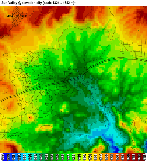
Below is the Elevation map of Sun Valley, which displays elevation range with different colors. Scale of the first map is from 1324 to 1642 m (4344 to 5387 ft) with average elevation of 1486.3 meters (=4876 ft) [note 1]
These maps also provides idea of topography and contour of this city, they are displayed at different zoom levels. More info about maps, scale and edge coordinates you can find below images.
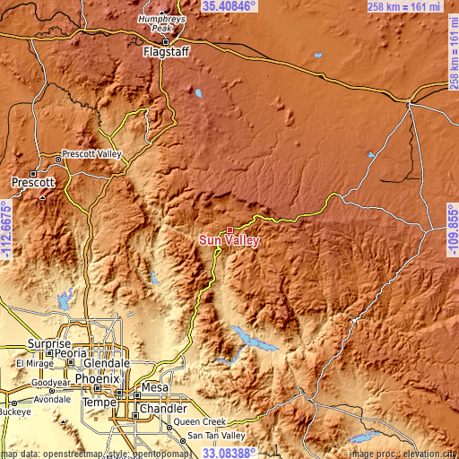
| \ | Map #1 | Topo.Map |
| Scale [m] | 1324..1642 m | × |
| Scale [ft] | 4344..5387 ft | × |
| Average | 1486.3 m = 4876 ft | × |
| Width | 8.08 km = 5 mi | 258.5 km = 160.6 mi |
| Height | 8.08 km = 5 mi | 258.5 km = 160.6 mi |
| ↑Max Latitude | 34.290515° | 35.40846° |
| Latitude at center | 34.2542° | 34.2542° |
| ↓Min Latitude | 34.217869° | 33.08388° |
| ← Min Longitude | -111.305195° | -112.6675° |
| Longitude center | -111.26125° | -111.26125° |
| →Max Longitude | -111.217305° | -109.855° |
Nearby cities:
Cities around Sun Valley sort by population:
• Payson elevation 1498 m
6.4 km,  246°
246°
• Camp Verde 959 m
64.4 km,  302°
302°
• Big Park 1239 m
74.4 km,  321°
321°
• Village of Oak Creek (Big Park) 1239 m
74.4 km, 321°
• Lake Montezuma 1051 m
63.3 km,  311°
311°
• Carefree 729 m
77.3 km,  231°
231°
• Heber-Overgaard 2021 m
66 km,  74°
74°
• Star Valley 1415 m
0.3 km, 69°
• Pine 1636 m
23 km, 309°
• Rio Verde 494 m
70.4 km,  212°
212°
• Cibecue 1508 m
75.1 km,  108°
108°
• Tonto Basin 683 m
47.1 km,  183°
183°
Multilingual:
 En español:
Sun Valley elevación 1420 m.
 En France:
Sun Valley élévation 1420 m.
 Auf Deutsch:
Sun Valley höhe über dem Meeresspiegel ist 1420 m.

Sources and notes:
- [note 1] Map square and city borders are not equal. Map elevation data is calculated only from area inside that square.
- [src 1] Elevation data from geonames database provided with same terms of usage.
- [src 2] The elevation map of Sun Valley is generated using elevation data from NASA's 3 arcsec (90m) resolution SRTM data.
- [src 3] Base (background) map © OpenStreetMap contributors tiles are generated by Geofabrik and OpenTopoMap.
Copyright & License:
This Sun Valley Elevation Map is licensed under CC BY-SA. You may reuse any part from this page, if you give a proper credit by linking to this URL:
 More info on terms of use page.