Casa Grande elevation
Casa Grande (Arizona, Pinal County), United States elevation is 423 meters and Casa Grande elevation in feet is 1388 ft above sea level [src 1]. Casa Grande is a populated place (feature code) with elevation that is 144 meters (472 ft) bigger than average city elevation in United States.
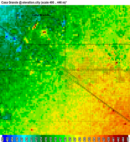
Below is the Elevation map of Casa Grande, which displays elevation range with different colors. Scale of the first map is from 400 to 446 m (1312 to 1463 ft) with average elevation of 422.9 meters (=1387 ft) [note 1]
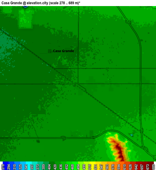
These maps also provides idea of topography and contour of this city, they are displayed at different zoom levels. More info about maps, scale and edge coordinates you can find below images.
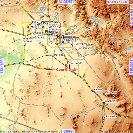
| \ | Map #1 | Map #2 | Topo.Map |
| Scale [m] | 400..446 m | 278..689 m | × |
| Scale [ft] | 1312..1463 ft | 912..2260 ft | × |
| Average | 422.9 m = 1387 ft | 428.2 m = 1405 ft | × |
| Width | 8.21 km = 5.1 mi | 16.41 km = 10.2 mi | 262.6 km = 163.2 mi |
| Height | 8.21 km = 5.1 mi | 16.41 km = 10.2 mi | 262.6 km = 163.2 mi |
| ↑Max Latitude | 32.916398° | 32.953281° | 34.05257° |
| Latitude at center | 32.8795° | 32.8795° | 32.8795° |
| ↓Min Latitude | 32.842586° | 32.805657° | 31.69069° |
| ← Min Longitude | -111.801295° | -111.845241° | -113.1636° |
| Longitude center | -111.75735° | -111.75735° | -111.75735° |
| →Max Longitude | -111.713405° | -111.669459° | -110.3511° |
Nearby cities:
Cities around Casa Grande sort by population:
• Chandler elevation 368 m
48.1 km,  350°
350°
• San Tan Valley 461 m
40.7 km,  31°
31°
• Maricopa 356 m
33.6 km,  306°
306°
• Queen Creek 428 m
42.6 km,  15°
15°
• Florence 453 m
38.4 km,  63°
63°
• Eloy 472 m
23.4 km,  125°
125°
• Sun Lakes 362 m
38.5 km,  343°
343°
• Coolidge 433 m
24.9 km, 63°
• Arizona City 457 m
15.9 km,  149°
149°
• Sacaton 390 m
22 km,  4°
4°
• Casa Blanca 361 m
29.4 km, 335°
• Blackwater 419 m
23.5 km,  44°
44°
Multilingual:
 En español:
Casa Grande elevación 423 m.
 En France:
Casa Grande élévation 423 m.
 Auf Deutsch:
Casa Grande höhe über dem Meeresspiegel ist 423 m.

Sources and notes:
- [note 1] Map square and city borders are not equal. Map elevation data is calculated only from area inside that square.
- [src 1] Elevation data from geonames database provided with same terms of usage.
- [src 2] The elevation map of Casa Grande is generated using elevation data from NASA's 3 arcsec (90m) resolution SRTM data.
- [src 3] Base (background) map © OpenStreetMap contributors tiles are generated by Geofabrik and OpenTopoMap.
Copyright & License:
This Casa Grande Elevation Map is licensed under CC BY-SA. You may reuse any part from this page, if you give a proper credit by linking to this URL:
 More info on terms of use page.