Winneconne elevation
Winneconne (Wisconsin, Winnebago County), United States elevation is 231 meters and Winneconne elevation in feet is 758 ft above sea level [src 1]. Winneconne is a populated place (feature code) with elevation that is 48 meters (157 ft) smaller than average city elevation in United States.
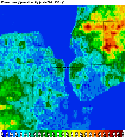
Below is the Elevation map of Winneconne, which displays elevation range with different colors. Scale of the first map is from 224 to 259 m (735 to 850 ft) with average elevation of 231.3 meters (=759 ft) [note 1]
These maps also provides idea of topography and contour of this city, they are displayed at different zoom levels. More info about maps, scale and edge coordinates you can find below images.
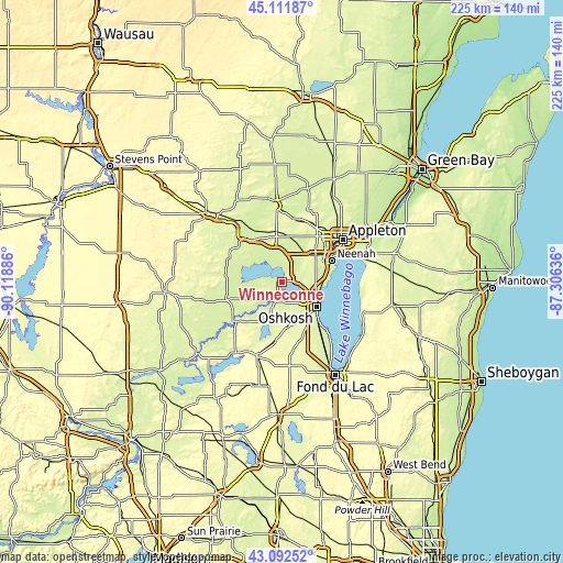
| \ | Map #1 | Topo.Map |
| Scale [m] | 224..259 m | × |
| Scale [ft] | 735..850 ft | × |
| Average | 231.3 m = 759 ft | × |
| Width | 7.02 km = 4.4 mi | 224.5 km = 139.5 mi |
| Height | 7.02 km = 4.4 mi | 224.5 km = 139.5 mi |
| ↑Max Latitude | 44.142364° | 45.11187° |
| Latitude at center | 44.11082° | 44.11082° |
| ↓Min Latitude | 44.079259° | 43.09252° |
| ← Min Longitude | -88.756555° | -90.11886° |
| Longitude center | -88.71261° | -88.71261° |
| →Max Longitude | -88.668665° | -87.30636° |
Nearby cities:
Cities around Winneconne sort by population:
• Appleton elevation 243 m
29.1 km,  54°
54°
• Oshkosh 237 m
16.6 km,  125°
125°
• Neenah 233 m
21.6 km,  67°
67°
• Menasha 234 m
23.5 km,  64°
64°
• Ripon 286 m
31.5 km,  198°
198°
• New London 235 m
31.4 km,  356°
356°
• Berlin 250 m
24.3 km,  229°
229°
• Omro 231 m
8.3 km, 197°
• Hortonville 245 m
25.6 km,  13°
13°
• Redgranite 242 m
31.8 km,  256°
256°
• Weyauwega 244 m
29.3 km,  323°
323°
• Eldorado 271 m
32.6 km,  167°
167°
Multilingual:
 En español:
Winneconne elevación 231 m.
 En France:
Winneconne élévation 231 m.
 Auf Deutsch:
Winneconne höhe über dem Meeresspiegel ist 231 m.

Sources and notes:
- [note 1] Map square and city borders are not equal. Map elevation data is calculated only from area inside that square.
- [src 1] Elevation data from geonames database provided with same terms of usage.
- [src 2] The elevation map of Winneconne is generated using elevation data from NASA's 3 arcsec (90m) resolution SRTM data.
- [src 3] Base (background) map © OpenStreetMap contributors tiles are generated by Geofabrik and OpenTopoMap.
Copyright & License:
This Winneconne Elevation Map is licensed under CC BY-SA. You may reuse any part from this page, if you give a proper credit by linking to this URL:
 More info on terms of use page.