Wautoma elevation
Wautoma (Wisconsin, Waushara County), United States elevation is 268 meters and Wautoma elevation in feet is 879 ft above sea level [src 1]. Wautoma is a seat of a second-order administrative division (feature code) with elevation that is 11 meters (36 ft) smaller than average city elevation in United States.
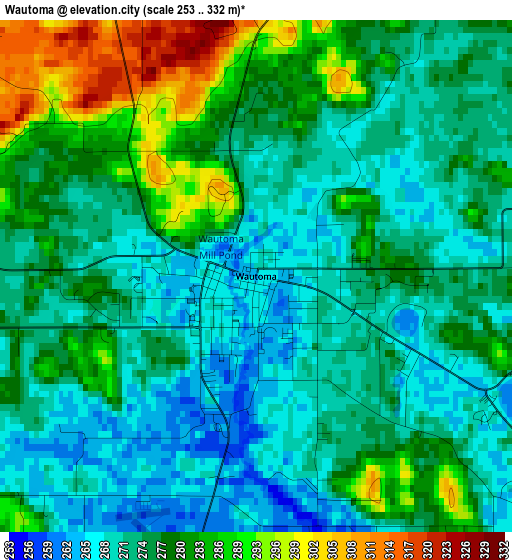
Below is the Elevation map of Wautoma, which displays elevation range with different colors. Scale of the first map is from 253 to 332 m (830 to 1089 ft) with average elevation of 276.6 meters (=907 ft) [note 1]
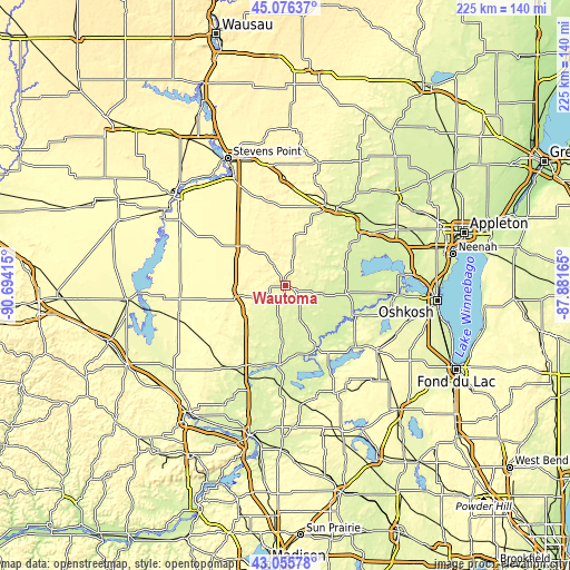
These maps also provides idea of topography and contour of this city, they are displayed at different zoom levels. More info about maps, scale and edge coordinates you can find below images.
| \ | Map #1 | Topo.Map |
| Scale [m] | 253..332 m | × |
| Scale [ft] | 830..1089 ft | × |
| Average | 276.6 m = 907 ft | × |
| Width | 7.02 km = 4.4 mi | 224.7 km = 139.6 mi |
| Height | 7.02 km = 4.4 mi | 224.7 km = 139.6 mi |
| ↑Max Latitude | 44.106263° | 45.07637° |
| Latitude at center | 44.0747° | 44.0747° |
| ↓Min Latitude | 44.04312° | 43.05578° |
| ← Min Longitude | -89.331845° | -90.69415° |
| Longitude center | -89.2879° | -89.2879° |
| →Max Longitude | -89.243955° | -87.88165° |
Nearby cities:
Cities around Wautoma sort by population:
• Waupaca elevation 259 m
35.4 km,  27°
27°
• Berlin 250 m
30 km,  113°
113°
• Silver Lake 274 m
5.4 km, 113°
• Redgranite 242 m
15.6 km,  103°
103°
• Weyauwega 244 m
39.4 km,  45°
45°
• King 276 m
31.5 km,  21°
21°
• Montello 244 m
31.6 km,  184°
184°
• Westfield 270 m
26.9 km,  217°
217°
• Dakota 260 m
10.9 km,  210°
210°
• Princeton 242 m
28.2 km,  151°
151°
• Mount Morris 274 m
8.9 km,  60°
60°
• Green Lake 248 m
36.7 km,  134°
134°
Multilingual:
 En español:
Wautoma elevación 268 m.
 En France:
Wautoma élévation 268 m.


Sources and notes:
- [note 1] Map square and city borders are not equal. Map elevation data is calculated only from area inside that square.
- [src 1] Elevation data from geonames database provided with same terms of usage.
- [src 2] The elevation map of Wautoma is generated using elevation data from NASA's 3 arcsec (90m) resolution SRTM data.
- [src 3] Base (background) map © OpenStreetMap contributors tiles are generated by Geofabrik and OpenTopoMap.
Copyright & License:
This Wautoma Elevation Map is licensed under CC BY-SA. You may reuse any part from this page, if you give a proper credit by linking to this URL:
 More info on terms of use page.