Tomahawk elevation
Tomahawk (Wisconsin, Lincoln County), United States elevation is 443 meters and Tomahawk elevation in feet is 1453 ft above sea level [src 1]. Tomahawk is a populated place (feature code) with elevation that is 164 meters (538 ft) bigger than average city elevation in United States.
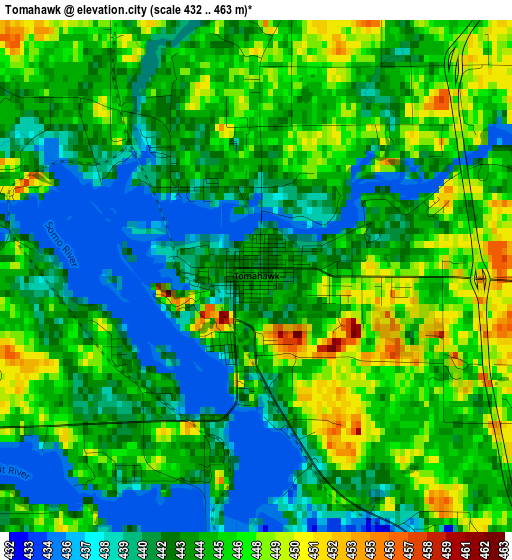
Below is the Elevation map of Tomahawk, which displays elevation range with different colors. Scale of the first map is from 432 to 463 m (1417 to 1519 ft) with average elevation of 443.6 meters (=1455 ft) [note 1]
These maps also provides idea of topography and contour of this city, they are displayed at different zoom levels. More info about maps, scale and edge coordinates you can find below images.
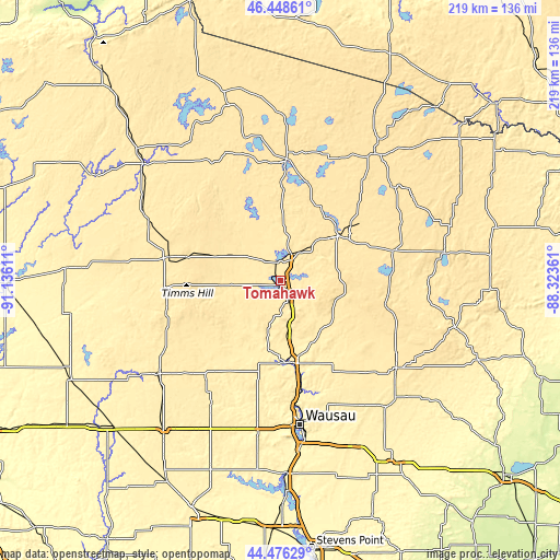
| \ | Map #1 | Topo.Map |
| Scale [m] | 432..463 m | × |
| Scale [ft] | 1417..1519 ft | × |
| Average | 443.6 m = 1455 ft | × |
| Width | 6.85 km = 4.3 mi | 219.3 km = 136.3 mi |
| Height | 6.85 km = 4.3 mi | 219.3 km = 136.3 mi |
| ↑Max Latitude | 45.501889° | 46.44861° |
| Latitude at center | 45.47108° | 45.47108° |
| ↓Min Latitude | 45.440254° | 44.47629° |
| ← Min Longitude | -89.773805° | -91.13611° |
| Longitude center | -89.72986° | -89.72986° |
| →Max Longitude | -89.685915° | -88.32361° |
Nearby cities:
Cities around Tomahawk sort by population:
• Wausau elevation 371 m
57.5 km,  172°
172°
• Merrill 393 m
32.5 km, 173°
• Antigo 459 m
58.2 km,  129°
129°
• Rhinelander 473 m
30.8 km,  53°
53°
• Rib Mountain 404 m
62.2 km,  176°
176°
• Medford 450 m
60.4 km,  232°
232°
• Maine 431 m
49.5 km, 176°
• Lac du Flambeau 490 m
56.9 km,  347°
347°
• Marathon 394 m
60.9 km,  188°
188°
• Phillips 436 m
57.9 km,  295°
295°
• Athens 429 m
55.7 km,  208°
208°
• Nashville 519 m
55.2 km,  84°
84°
Multilingual:
 En español:
Tomahawk elevación 443 m.
 En France:
Tomahawk élévation 443 m.
 Auf Deutsch:
Tomahawk höhe über dem Meeresspiegel ist 443 m.

Sources and notes:
- [note 1] Map square and city borders are not equal. Map elevation data is calculated only from area inside that square.
- [src 1] Elevation data from geonames database provided with same terms of usage.
- [src 2] The elevation map of Tomahawk is generated using elevation data from NASA's 3 arcsec (90m) resolution SRTM data.
- [src 3] Base (background) map © OpenStreetMap contributors tiles are generated by Geofabrik and OpenTopoMap.
Copyright & License:
This Tomahawk Elevation Map is licensed under CC BY-SA. You may reuse any part from this page, if you give a proper credit by linking to this URL:
 More info on terms of use page.