Merrill elevation
Merrill (Wisconsin, Lincoln County), United States elevation is 393 meters and Merrill elevation in feet is 1289 ft above sea level [src 1]. Merrill is a seat of a second-order administrative division (feature code) with elevation that is 114 meters (374 ft) bigger than average city elevation in United States.
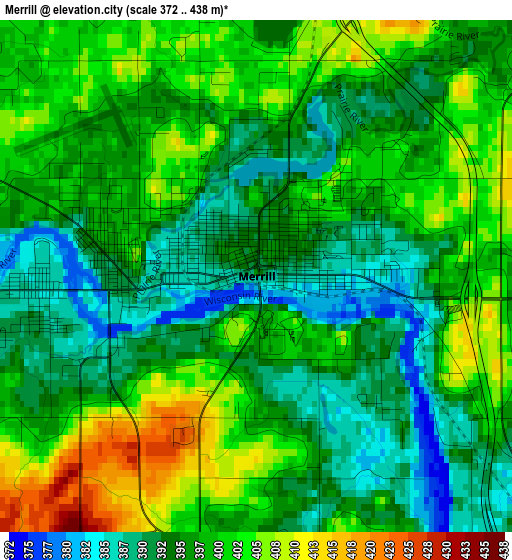
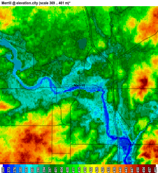
Below is the Elevation map of Merrill, which displays elevation range with different colors. Scale of the first map is from 372 to 438 m (1220 to 1437 ft) with average elevation of 397.4 meters (=1304 ft) [note 1]
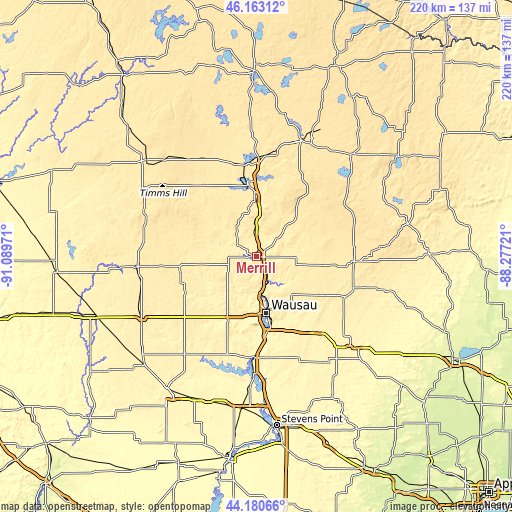
These maps also provides idea of topography and contour of this city, they are displayed at different zoom levels. More info about maps, scale and edge coordinates you can find below images.
| \ | Map #1 | Map #2 | Topo.Map |
| Scale [m] | 372..438 m | 369..461 m | × |
| Scale [ft] | 1220..1437 ft | 1211..1512 ft | × |
| Average | 397.4 m = 1304 ft | 407 m = 1335 ft | × |
| Width | 6.89 km = 4.3 mi | 13.78 km = 8.6 mi | 220.4 km = 136.9 mi |
| Height | 6.89 km = 4.3 mi | 13.78 km = 8.6 mi | 220.4 km = 136.9 mi |
| ↑Max Latitude | 45.211488° | 45.242438° | 46.16312° |
| Latitude at center | 45.18052° | 45.18052° | 45.18052° |
| ↓Min Latitude | 45.149536° | 45.118534° | 44.18066° |
| ← Min Longitude | -89.727405° | -89.771351° | -91.08971° |
| Longitude center | -89.68346° | -89.68346° | -89.68346° |
| →Max Longitude | -89.639515° | -89.595569° | -88.27721° |
Nearby cities:
Cities around Merrill sort by population:
• Wausau elevation 371 m
25 km,  170°
170°
• Weston 393 m
33.9 km,  161°
161°
• Kronenwetter 370 m
40.5 km, 169°
• Rib Mountain 404 m
29.8 km,  178°
178°
• Rothschild 370 m
33 km, 171°
• Evergreen 361 m
37.8 km, 174°
• Tomahawk 443 m
32.5 km,  353°
353°
• Maine 431 m
17.1 km, 181°
• Schofield 367 m
30.7 km, 168°
• Marathon 394 m
30.5 km,  203°
203°
• Edgar 397 m
35.7 km,  217°
217°
• Athens 429 m
34.8 km,  241°
241°
Multilingual:
 En español:
Merrill elevación 393 m.
 En France:
Merrill élévation 393 m.


Sources and notes:
- [note 1] Map square and city borders are not equal. Map elevation data is calculated only from area inside that square.
- [src 1] Elevation data from geonames database provided with same terms of usage.
- [src 2] The elevation map of Merrill is generated using elevation data from NASA's 3 arcsec (90m) resolution SRTM data.
- [src 3] Base (background) map © OpenStreetMap contributors tiles are generated by Geofabrik and OpenTopoMap.
Copyright & License:
This Merrill Elevation Map is licensed under CC BY-SA. You may reuse any part from this page, if you give a proper credit by linking to this URL:
 More info on terms of use page.