Roberts elevation
Roberts (Wisconsin, Saint Croix County), United States elevation is 316 meters and Roberts elevation in feet is 1037 ft above sea level [src 1]. Roberts is a populated place (feature code) with elevation that is 37 meters (121 ft) bigger than average city elevation in United States.
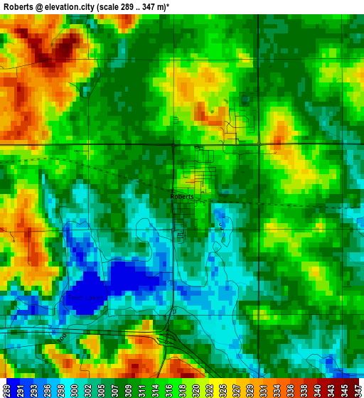
Below is the Elevation map of Roberts, which displays elevation range with different colors. Scale of the first map is from 289 to 347 m (948 to 1138 ft) with average elevation of 311.9 meters (=1023 ft) [note 1]
These maps also provides idea of topography and contour of this city, they are displayed at different zoom levels. More info about maps, scale and edge coordinates you can find below images.
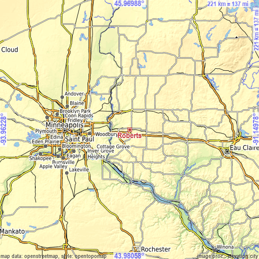
| \ | Map #1 | Topo.Map |
| Scale [m] | 289..347 m | × |
| Scale [ft] | 948..1138 ft | × |
| Average | 311.9 m = 1023 ft | × |
| Width | 6.91 km = 4.3 mi | 221.2 km = 137.4 mi |
| Height | 6.91 km = 4.3 mi | 221.2 km = 137.4 mi |
| ↑Max Latitude | 45.014934° | 45.96988° |
| Latitude at center | 44.98386° | 44.98386° |
| ↓Min Latitude | 44.952769° | 43.98058° |
| ← Min Longitude | -92.599975° | -93.96228° |
| Longitude center | -92.55603° | -92.55603° |
| →Max Longitude | -92.512085° | -91.14978° |
Nearby cities:
Cities around Roberts sort by population:
• River Falls elevation 270 m
14.6 km,  201°
201°
• Hudson 218 m
15.8 km,  266°
266°
• New Richmond 298 m
15.5 km,  5°
5°
• Oak Park Heights 238 m
19.4 km,  285°
285°
• Baldwin 341 m
14.4 km,  97°
97°
• North Hudson 225 m
15.8 km, 273°
• Bayport 214 m
18.2 km,  283°
283°
• Afton 215 m
20 km,  243°
243°
• Somerset 257 m
18.1 km,  329°
329°
• Hammond 352 m
9.5 km,  93°
93°
• Lakeland 222 m
16.8 km,  259°
259°
• Lake Saint Croix Beach 211 m
18 km,  247°
247°
Multilingual:
 En español:
Roberts elevación 316 m.
 En France:
Roberts élévation 316 m.


Sources and notes:
- [note 1] Map square and city borders are not equal. Map elevation data is calculated only from area inside that square.
- [src 1] Elevation data from geonames database provided with same terms of usage.
- [src 2] The elevation map of Roberts is generated using elevation data from NASA's 3 arcsec (90m) resolution SRTM data.
- [src 3] Base (background) map © OpenStreetMap contributors tiles are generated by Geofabrik and OpenTopoMap.
Copyright & License:
This Roberts Elevation Map is licensed under CC BY-SA. You may reuse any part from this page, if you give a proper credit by linking to this URL:
 More info on terms of use page.