Lancaster elevation
Lancaster (Wisconsin, Grant County), United States elevation is 337 meters and Lancaster elevation in feet is 1106 ft above sea level [src 1]. Lancaster is a seat of a second-order administrative division (feature code) with elevation that is 58 meters (190 ft) bigger than average city elevation in United States.
Below is the Elevation map of Lancaster, which displays elevation range with different colors. Scale of the first map is from 241 to 358 m (791 to 1175 ft) with average elevation of 314.6 meters (=1032 ft) [note 1]
These maps also provides idea of topography and contour of this city, they are displayed at different zoom levels. More info about maps, scale and edge coordinates you can find below images.
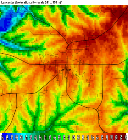
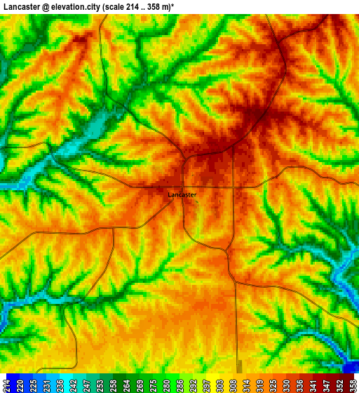
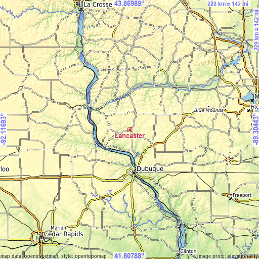
| \ | Map #1 | Map #2 | Topo.Map |
| Scale [m] | 241..358 m | 214..358 m | × |
| Scale [ft] | 791..1175 ft | 702..1175 ft | × |
| Average | 314.6 m = 1032 ft | 301.7 m = 990 ft | × |
| Width | 7.16 km = 4.4 mi | 14.33 km = 8.9 mi | 229.3 km = 142.5 mi |
| Height | 7.16 km = 4.4 mi | 14.33 km = 8.9 mi | 229.3 km = 142.5 mi |
| ↑Max Latitude | 42.879701° | 42.911895° | 43.86989° |
| Latitude at center | 42.84749° | 42.84749° | 42.84749° |
| ↓Min Latitude | 42.815262° | 42.783018° | 41.80788° |
| ← Min Longitude | -90.754625° | -90.798571° | -92.11693° |
| Longitude center | -90.71068° | -90.71068° | -90.71068° |
| →Max Longitude | -90.666735° | -90.622789° | -89.30443° |
Nearby cities:
Cities around Lancaster sort by population:
• Dubuque elevation 194 m
38.8 km,  174°
174°
• Platteville 300 m
22.8 km,  123°
123°
• Prairie du Chien 197 m
41.8 km,  302°
302°
• Asbury 286 m
37.2 km,  185°
185°
• Boscobel 207 m
31.9 km,  0°
0°
• Mineral Point 318 m
43.3 km,  88°
88°
• Fennimore 365 m
15.8 km,  16°
16°
• Cuba City 309 m
35.4 km,  139°
139°
• Guttenberg 194 m
32.5 km,  257°
257°
• East Dubuque 190 m
39.9 km, 172°
• Hazel Green 296 m
41.6 km,  147°
147°
• Dickeyville 291 m
26.3 km,  158°
158°
Multilingual:
 En español:
Lancaster elevación 337 m.
 En France:
Lancaster élévation 337 m.
 Auf Deutsch:
Lancaster höhe über dem Meeresspiegel ist 337 m.

Sources and notes:
- [note 1] Map square and city borders are not equal. Map elevation data is calculated only from area inside that square.
- [src 1] Elevation data from geonames database provided with same terms of usage.
- [src 2] The elevation map of Lancaster is generated using elevation data from NASA's 3 arcsec (90m) resolution SRTM data.
- [src 3] Base (background) map © OpenStreetMap contributors tiles are generated by Geofabrik and OpenTopoMap.
Copyright & License:
This Lancaster Elevation Map is licensed under CC BY-SA. You may reuse any part from this page, if you give a proper credit by linking to this URL:
 More info on terms of use page.