Kenosha elevation
Kenosha (Wisconsin, Kenosha County), United States elevation is 185 meters and Kenosha elevation in feet is 607 ft above sea level [src 1]. Kenosha is a seat of a second-order administrative division (feature code) with elevation that is 94 meters (308 ft) smaller than average city elevation in United States.
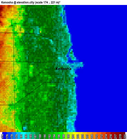
Below is the Elevation map of Kenosha, which displays elevation range with different colors. Scale of the first map is from 174 to 221 m (571 to 725 ft) with average elevation of 185.3 meters (=608 ft) [note 1]
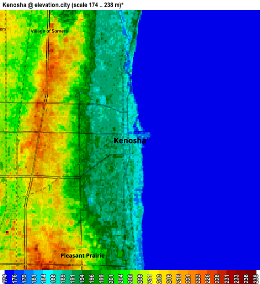
These maps also provides idea of topography and contour of this city, they are displayed at different zoom levels. More info about maps, scale and edge coordinates you can find below images.
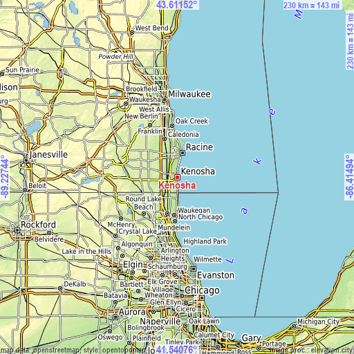
| \ | Map #1 | Map #2 | Topo.Map |
| Scale [m] | 174..221 m | 174..238 m | × |
| Scale [ft] | 571..725 ft | 571..781 ft | × |
| Average | 185.3 m = 608 ft | 190 m = 623 ft | × |
| Width | 7.2 km = 4.5 mi | 14.39 km = 8.9 mi | 230.2 km = 143 mi |
| Height | 7.2 km = 4.5 mi | 14.39 km = 8.9 mi | 230.2 km = 143 mi |
| ↑Max Latitude | 42.617088° | 42.649418° | 43.61152° |
| Latitude at center | 42.58474° | 42.58474° | 42.58474° |
| ↓Min Latitude | 42.552376° | 42.519995° | 41.54076° |
| ← Min Longitude | -87.865135° | -87.909081° | -89.22744° |
| Longitude center | -87.82119° | -87.82119° | -87.82119° |
| →Max Longitude | -87.777245° | -87.733299° | -86.41494° |
Nearby cities:
Cities around Kenosha sort by population:
• Racine elevation 192 m
16 km,  11°
11°
• Mount Pleasant 218 m
12.8 km,  347°
347°
• Zion 201 m
15.4 km,  183°
183°
• Pleasant Prairie 214 m
9.8 km,  249°
249°
• Beach Park 215 m
18.3 km,  189°
189°
• Somers 218 m
9.6 km,  310°
310°
• Sturtevant 215 m
14 km,  334°
334°
• Winthrop Harbor 195 m
11.8 km, 180°
• Bristol 240 m
18.9 km,  261°
261°
• Union Grove 237 m
22.1 km,  301°
301°
• Wadsworth 218 m
19.3 km,  205°
205°
• Franksville 225 m
20.9 km,  338°
338°
Multilingual:
 En español:
Kenosha elevación 185 m.
 En France:
Kenosha élévation 185 m.


Sources and notes:
- [note 1] Map square and city borders are not equal. Map elevation data is calculated only from area inside that square.
- [src 1] Elevation data from geonames database provided with same terms of usage.
- [src 2] The elevation map of Kenosha is generated using elevation data from NASA's 3 arcsec (90m) resolution SRTM data.
- [src 3] Base (background) map © OpenStreetMap contributors tiles are generated by Geofabrik and OpenTopoMap.
Copyright & License:
This Kenosha Elevation Map is licensed under CC BY-SA. You may reuse any part from this page, if you give a proper credit by linking to this URL:
 More info on terms of use page.