Montgomery elevation
Montgomery (Vermont, Franklin County), United States elevation is 155 meters and Montgomery elevation in feet is 509 ft above sea level [src 1]. Montgomery is a populated place (feature code) with elevation that is 124 meters (407 ft) smaller than average city elevation in United States.
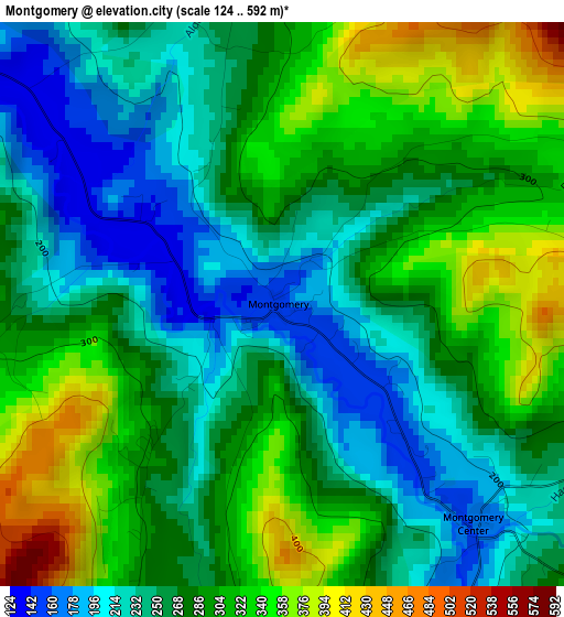
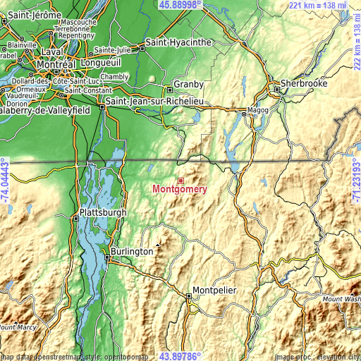
Below is the Elevation map of Montgomery, which displays elevation range with different colors. Scale of the first map is from 124 to 592 m (407 to 1942 ft) with average elevation of 277.5 meters (=910 ft) [note 1]
These maps also provides idea of topography and contour of this city, they are displayed at different zoom levels. More info about maps, scale and edge coordinates you can find below images.
| \ | Map #1 | Topo.Map |
| Scale [m] | 124..592 m | × |
| Scale [ft] | 407..1942 ft | × |
| Average | 277.5 m = 910 ft | × |
| Width | 6.92 km = 4.3 mi | 221.5 km = 137.6 mi |
| Height | 6.92 km = 4.3 mi | 221.5 km = 137.6 mi |
| ↑Max Latitude | 44.933668° | 45.88998° |
| Latitude at center | 44.90255° | 44.90255° |
| ↓Min Latitude | 44.871415° | 43.89786° |
| ← Min Longitude | -72.682125° | -74.04443° |
| Longitude center | -72.63818° | -72.63818° |
| →Max Longitude | -72.594235° | -71.23193° |
Nearby cities:
Cities around Montgomery sort by population:
• Saint Albans elevation 127 m
36.5 km,  253°
253°
• Morristown 234 m
38.4 km,  178°
178°
• Newport 206 m
34.3 km,  83°
83°
• Stowe 222 m
48.8 km, 184°
• Swanton 45 m
38.3 km,  272°
272°
• Morrisville 208 m
38 km, 175°
• Milton 93 m
47.4 km,  231°
231°
• Johnson 154 m
29.9 km,  186°
186°
• Richford 139 m
10.8 km,  346°
346°
• Hardwick 252 m
49.1 km,  154°
154°
• Enosburg Falls 129 m
13.3 km, 272°
• Hyde Park 206 m
34.4 km, 177°
Multilingual:
 En español:
Montgomery elevación 155 m.
 En France:
Montgomery élévation 155 m.
 Auf Deutsch:
Montgomery höhe über dem Meeresspiegel ist 155 m.

Sources and notes:
- [note 1] Map square and city borders are not equal. Map elevation data is calculated only from area inside that square.
- [src 1] Elevation data from geonames database provided with same terms of usage.
- [src 2] The elevation map of Montgomery is generated using elevation data from NASA's 3 arcsec (90m) resolution SRTM data.
- [src 3] Base (background) map © OpenStreetMap contributors tiles are generated by Geofabrik and OpenTopoMap.
Copyright & License:
This Montgomery Elevation Map is licensed under CC BY-SA. You may reuse any part from this page, if you give a proper credit by linking to this URL:
 More info on terms of use page.