Hartford elevation
Hartford (Vermont, Windsor County), United States elevation is 126 meters and Hartford elevation in feet is 413 ft above sea level [src 1]. Hartford is a populated place (feature code) with elevation that is 153 meters (502 ft) smaller than average city elevation in United States.
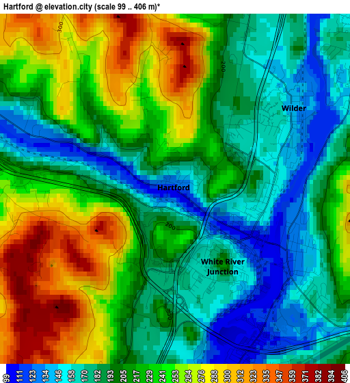
Below is the Elevation map of Hartford, which displays elevation range with different colors. Scale of the first map is from 99 to 406 m (325 to 1332 ft) with average elevation of 215.5 meters (=707 ft) [note 1]
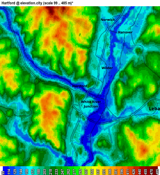
These maps also provides idea of topography and contour of this city, they are displayed at different zoom levels. More info about maps, scale and edge coordinates you can find below images.
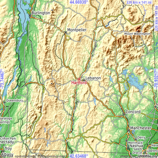
| \ | Map #1 | Map #2 | Topo.Map |
| Scale [m] | 99..406 m | 99..485 m | × |
| Scale [ft] | 325..1332 ft | 325..1591 ft | × |
| Average | 215.5 m = 707 ft | 230.6 m = 757 ft | × |
| Width | 7.07 km = 4.4 mi | 14.14 km = 8.8 mi | 226.2 km = 140.6 mi |
| Height | 7.07 km = 4.4 mi | 14.14 km = 8.8 mi | 226.2 km = 140.6 mi |
| ↑Max Latitude | 43.692413° | 43.72418° | 44.66935° |
| Latitude at center | 43.66063° | 43.66063° | 43.66063° |
| ↓Min Latitude | 43.62883° | 43.597013° | 42.63468° |
| ← Min Longitude | -72.382365° | -72.426311° | -73.74467° |
| Longitude center | -72.33842° | -72.33842° | -72.33842° |
| →Max Longitude | -72.294475° | -72.250529° | -70.93217° |
Nearby cities:
Cities around Hartford sort by population:
• Lebanon elevation 183 m
7.3 km,  106°
106°
• Claremont 152 m
31.6 km,  181°
181°
• Hanover 168 m
6.1 km,  40°
40°
• Grantham 294 m
25 km,  139°
139°
• White River Junction 112 m
2 km,  130°
130°
• Windsor 103 m
20.4 km,  190°
190°
• Lyme 173 m
22.1 km, 41°
• Wilder 134 m
2.7 km,  60°
60°
• Enfield 250 m
15.8 km,  98°
98°
• Orford 129 m
31.5 km,  30°
30°
• Springfield 446 m
30.7 km, 126°
• Woodstock 217 m
15 km,  254°
254°
Multilingual:
 En español:
Hartford elevación 126 m.
 En France:
Hartford élévation 126 m.
 Auf Deutsch:
Hartford höhe über dem Meeresspiegel ist 126 m.

Sources and notes:
- [note 1] Map square and city borders are not equal. Map elevation data is calculated only from area inside that square.
- [src 1] Elevation data from geonames database provided with same terms of usage.
- [src 2] The elevation map of Hartford is generated using elevation data from NASA's 3 arcsec (90m) resolution SRTM data.
- [src 3] Base (background) map © OpenStreetMap contributors tiles are generated by Geofabrik and OpenTopoMap.
Copyright & License:
This Hartford Elevation Map is licensed under CC BY-SA. You may reuse any part from this page, if you give a proper credit by linking to this URL:
 More info on terms of use page.