Hanover elevation
Hanover (New Hampshire, Grafton County), United States elevation is 168 meters and Hanover elevation in feet is 551 ft above sea level [src 1]. Hanover is a populated place (feature code) with elevation that is 111 meters (364 ft) smaller than average city elevation in United States.
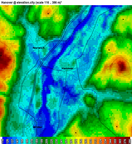
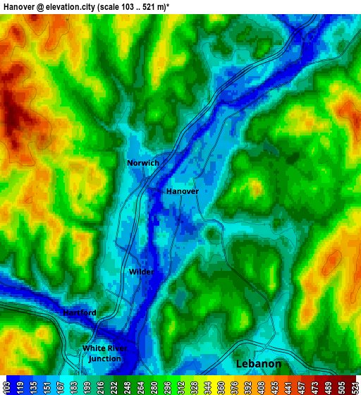
Below is the Elevation map of Hanover, which displays elevation range with different colors. Scale of the first map is from 116 to 386 m (381 to 1266 ft) with average elevation of 200.4 meters (=657 ft) [note 1]
These maps also provides idea of topography and contour of this city, they are displayed at different zoom levels. More info about maps, scale and edge coordinates you can find below images.
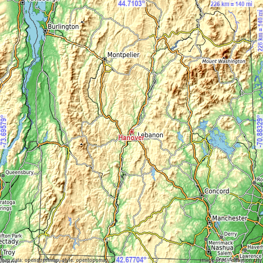
| \ | Map #1 | Map #2 | Topo.Map |
| Scale [m] | 116..386 m | 103..521 m | × |
| Scale [ft] | 381..1266 ft | 338..1709 ft | × |
| Average | 200.4 m = 657 ft | 252.7 m = 829 ft | × |
| Width | 7.06 km = 4.4 mi | 14.13 km = 8.8 mi | 226.1 km = 140.5 mi |
| Height | 7.06 km = 4.4 mi | 14.13 km = 8.8 mi | 226.1 km = 140.5 mi |
| ↑Max Latitude | 43.734051° | 43.765796° | 44.7103° |
| Latitude at center | 43.70229° | 43.70229° | 43.70229° |
| ↓Min Latitude | 43.670512° | 43.638717° | 42.67704° |
| ← Min Longitude | -72.333485° | -72.377431° | -73.69579° |
| Longitude center | -72.28954° | -72.28954° | -72.28954° |
| →Max Longitude | -72.245595° | -72.201649° | -70.88329° |
Nearby cities:
Cities around Hanover sort by population:
• Lebanon elevation 183 m
7.3 km,  155°
155°
• Hartford 126 m
6.1 km,  220°
220°
• Grantham 294 m
26.6 km,  152°
152°
• White River Junction 112 m
6.4 km,  201°
201°
• Windsor 103 m
25.8 km, 197°
• Lyme 173 m
16 km,  41°
41°
• Wilder 134 m
3.6 km,  205°
205°
• Enfield 250 m
13.6 km,  120°
120°
• Grafton 255 m
32.1 km, 119°
• Orford 129 m
25.6 km,  27°
27°
• Springfield 446 m
30.9 km,  138°
138°
• Woodstock 217 m
20.4 km,  244°
244°
Multilingual:
 En español:
Hanover elevación 168 m.
 En France:
Hanover élévation 168 m.


Sources and notes:
- [note 1] Map square and city borders are not equal. Map elevation data is calculated only from area inside that square.
- [src 1] Elevation data from geonames database provided with same terms of usage.
- [src 2] The elevation map of Hanover is generated using elevation data from NASA's 3 arcsec (90m) resolution SRTM data.
- [src 3] Base (background) map © OpenStreetMap contributors tiles are generated by Geofabrik and OpenTopoMap.
Copyright & License:
This Hanover Elevation Map is licensed under CC BY-SA. You may reuse any part from this page, if you give a proper credit by linking to this URL:
 More info on terms of use page.