Tea elevation
Tea (South Dakota, Lincoln County), United States elevation is 452 meters and Tea elevation in feet is 1483 ft above sea level [src 1]. Tea is a populated place (feature code) with elevation that is 173 meters (568 ft) bigger than average city elevation in United States.
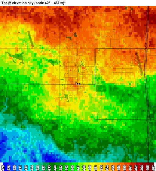
Below is the Elevation map of Tea, which displays elevation range with different colors. Scale of the first map is from 426 to 467 m (1398 to 1532 ft) with average elevation of 448.2 meters (=1470 ft) [note 1]
These maps also provides idea of topography and contour of this city, they are displayed at different zoom levels. More info about maps, scale and edge coordinates you can find below images.
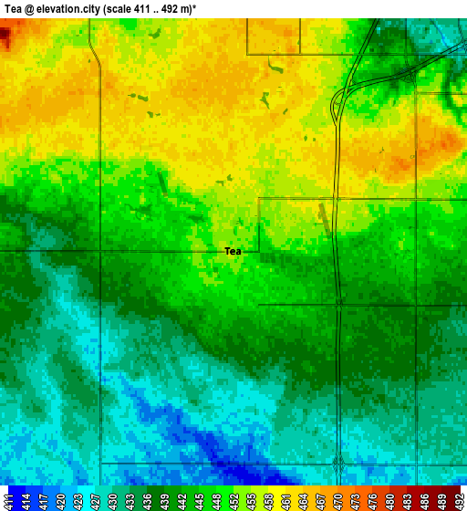
| \ | Map #1 | Map #2 | Topo.Map |
| Scale [m] | 426..467 m | 411..492 m | × |
| Scale [ft] | 1398..1532 ft | 1348..1614 ft | × |
| Average | 448.2 m = 1470 ft | 444.1 m = 1457 ft | × |
| Width | 7.09 km = 4.4 mi | 14.19 km = 8.8 mi | 227 km = 141.1 mi |
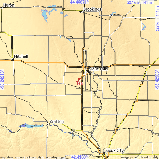
| Height | 7.1 km = 4.4 mi | 14.19 km = 8.8 mi | 227 km = 141.1 mi |
| ↑Max Latitude | 43.478267° | 43.510147° | 44.45871° |
| Latitude at center | 43.44637° | 43.44637° | 43.44637° |
| ↓Min Latitude | 43.414456° | 43.382526° | 42.4168° |
| ← Min Longitude | -96.879825° | -96.923771° | -98.24213° |
| Longitude center | -96.83588° | -96.83588° | -96.83588° |
| →Max Longitude | -96.791935° | -96.747989° | -95.42963° |
Nearby cities:
Cities around Tea sort by population:
• Sioux Falls elevation 449 m
15.9 km,  43°
43°
• Brandon 413 m
26.9 km,  52°
52°
• Harrisburg 436 m
11.3 km,  98°
98°
• Dell Rapids 460 m
43.5 km,  13°
13°
• Canton 389 m
25.5 km,  129°
129°
• Hartford 481 m
21.4 km,  336°
336°
• Lennox 411 m
11.2 km,  203°
203°
• Beresford 459 m
41 km,  172°
172°
• Crooks 483 m
24.4 km,  4°
4°
• Garretson 460 m
40.4 km, 41°
• Baltic 448 m
35.9 km, 12°
• Parker 411 m
24.9 km,  257°
257°
Multilingual:
 En español:
Tea elevación 452 m.
 En France:
Tea élévation 452 m.


Sources and notes:
- [note 1] Map square and city borders are not equal. Map elevation data is calculated only from area inside that square.
- [src 1] Elevation data from geonames database provided with same terms of usage.
- [src 2] The elevation map of Tea is generated using elevation data from NASA's 3 arcsec (90m) resolution SRTM data.
- [src 3] Base (background) map © OpenStreetMap contributors tiles are generated by Geofabrik and OpenTopoMap.
Copyright & License:
This Tea Elevation Map is licensed under CC BY-SA. You may reuse any part from this page, if you give a proper credit by linking to this URL:
 More info on terms of use page.