Tunkhannock elevation
Tunkhannock (Pennsylvania, Wyoming County), United States elevation is 189 meters and Tunkhannock elevation in feet is 620 ft above sea level [src 1]. Tunkhannock is a seat of a second-order administrative division (feature code) with elevation that is 90 meters (295 ft) smaller than average city elevation in United States.
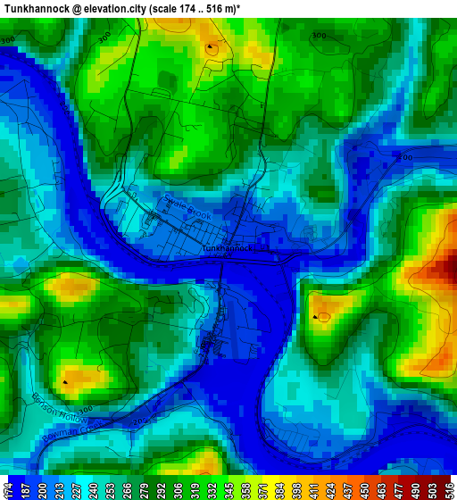
Below is the Elevation map of Tunkhannock, which displays elevation range with different colors. Scale of the first map is from 174 to 516 m (571 to 1693 ft) with average elevation of 263.4 meters (=864 ft) [note 1]
These maps also provides idea of topography and contour of this city, they are displayed at different zoom levels. More info about maps, scale and edge coordinates you can find below images.
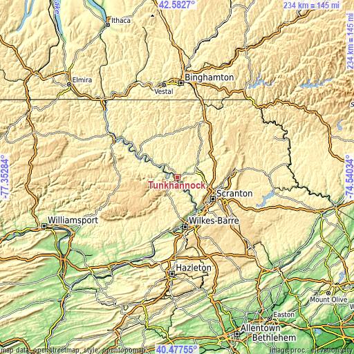
| \ | Map #1 | Topo.Map |
| Scale [m] | 174..516 m | × |
| Scale [ft] | 571..1693 ft | × |
| Average | 263.4 m = 864 ft | × |
| Width | 7.31 km = 4.5 mi | 234.1 km = 145.5 mi |
| Height | 7.31 km = 4.5 mi | 234.1 km = 145.5 mi |
| ↑Max Latitude | 41.571575° | 42.5827° |
| Latitude at center | 41.53869° | 41.53869° |
| ↓Min Latitude | 41.505788° | 40.47755° |
| ← Min Longitude | -75.990535° | -77.35284° |
| Longitude center | -75.94659° | -75.94659° |
| →Max Longitude | -75.902645° | -74.54034° |
Nearby cities:
Cities around Tunkhannock sort by population:
• Back Mountain elevation 392 m
22.9 km,  190°
190°
• Old Forge 226 m
25.7 km,  136°
136°
• Taylor 223 m
25.6 km,  128°
128°
• Clarks Summit 403 m
20.6 km,  105°
105°
• Harveys Lake 412 m
18.5 km,  200°
200°
• Dallas 346 m
22.6 km,  183°
183°
• West Wyoming 186 m
25.7 km,  160°
160°
• Chinchilla 357 m
23.5 km, 107°
• Shavertown 315 m
24.3 km, 178°
• Clarks Green 396 m
21.2 km,  103°
103°
• Factoryville 256 m
13.9 km,  78°
78°
• Dalton 301 m
17.5 km,  91°
91°
Multilingual:
 En español:
Tunkhannock elevación 189 m.
 En France:
Tunkhannock élévation 189 m.
 Auf Deutsch:
Tunkhannock höhe über dem Meeresspiegel ist 189 m.

Sources and notes:
- [note 1] Map square and city borders are not equal. Map elevation data is calculated only from area inside that square.
- [src 1] Elevation data from geonames database provided with same terms of usage.
- [src 2] The elevation map of Tunkhannock is generated using elevation data from NASA's 3 arcsec (90m) resolution SRTM data.
- [src 3] Base (background) map © OpenStreetMap contributors tiles are generated by Geofabrik and OpenTopoMap.
Copyright & License:
This Tunkhannock Elevation Map is licensed under CC BY-SA. You may reuse any part from this page, if you give a proper credit by linking to this URL:
 More info on terms of use page.