Topton elevation
Topton (Pennsylvania, Berks County), United States elevation is 148 meters and Topton elevation in feet is 486 ft above sea level [src 1]. Topton is a populated place (feature code) with elevation that is 131 meters (430 ft) smaller than average city elevation in United States.
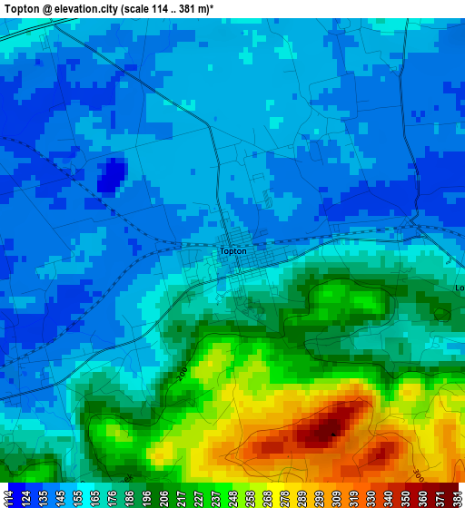
Below is the Elevation map of Topton, which displays elevation range with different colors. Scale of the first map is from 114 to 381 m (374 to 1250 ft) with average elevation of 176.5 meters (=579 ft) [note 1]
These maps also provides idea of topography and contour of this city, they are displayed at different zoom levels. More info about maps, scale and edge coordinates you can find below images.
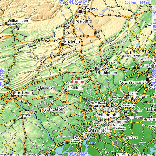
| \ | Map #1 | Topo.Map |
| Scale [m] | 114..381 m | × |
| Scale [ft] | 374..1250 ft | × |
| Average | 176.5 m = 579 ft | × |
| Width | 7.43 km = 4.6 mi | 237.8 km = 147.8 mi |
| Height | 7.43 km = 4.6 mi | 237.8 km = 147.8 mi |
| ↑Max Latitude | 40.536836° | 41.56416° |
| Latitude at center | 40.50343° | 40.50343° |
| ↓Min Latitude | 40.470007° | 39.42566° |
| ← Min Longitude | -75.745245° | -77.10755° |
| Longitude center | -75.7013° | -75.7013° |
| →Max Longitude | -75.657355° | -74.29505° |
Nearby cities:
Cities around Topton sort by population:
• Ancient Oaks elevation 121 m
10.6 km,  62°
62°
• Red Lion 228 m
7.6 km,  109°
109°
• Wescosville 129 m
14.4 km, 60°
• Kutztown 131 m
6.6 km,  283°
283°
• Breinigsville 129 m
7 km, 57°
• Fleetwood 134 m
11.3 km,  240°
240°
• Macungie 122 m
12.4 km,  83°
83°
• Alburtis 140 m
8.4 km, 84°
• Cetronia 104 m
17.2 km, 57°
• Trexlertown 123 m
9.5 km, 58°
• Oley 135 m
14.9 km,  210°
210°
• Bally 145 m
14.8 km,  139°
139°
Multilingual:
 En español:
Topton elevación 148 m.
 En France:
Topton élévation 148 m.


Sources and notes:
- [note 1] Map square and city borders are not equal. Map elevation data is calculated only from area inside that square.
- [src 1] Elevation data from geonames database provided with same terms of usage.
- [src 2] The elevation map of Topton is generated using elevation data from NASA's 3 arcsec (90m) resolution SRTM data.
- [src 3] Base (background) map © OpenStreetMap contributors tiles are generated by Geofabrik and OpenTopoMap.
Copyright & License:
This Topton Elevation Map is licensed under CC BY-SA. You may reuse any part from this page, if you give a proper credit by linking to this URL:
 More info on terms of use page.