Slippery Rock elevation
Slippery Rock (Pennsylvania, Butler County), United States elevation is 396 meters and Slippery Rock elevation in feet is 1299 ft above sea level [src 1]. Slippery Rock is a populated place (feature code) with elevation that is 117 meters (384 ft) bigger than average city elevation in United States.
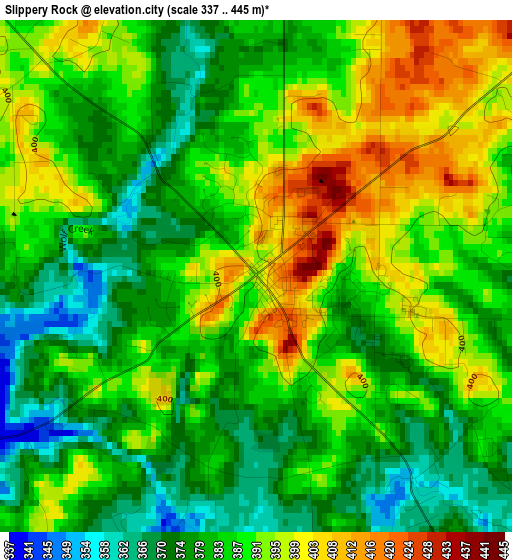
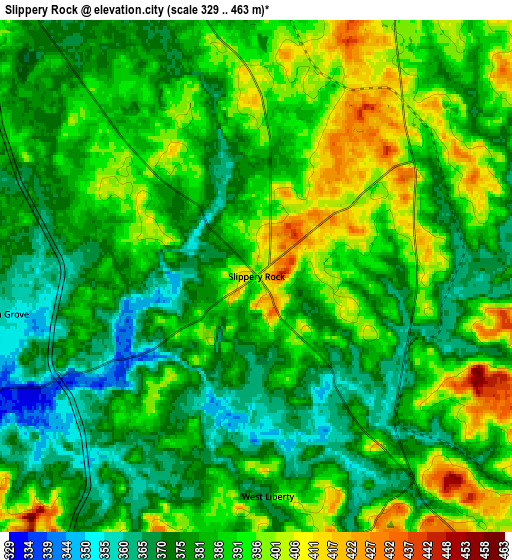
Below is the Elevation map of Slippery Rock, which displays elevation range with different colors. Scale of the first map is from 337 to 445 m (1106 to 1460 ft) with average elevation of 386.1 meters (=1267 ft) [note 1]
These maps also provides idea of topography and contour of this city, they are displayed at different zoom levels. More info about maps, scale and edge coordinates you can find below images.
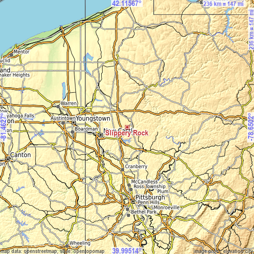
| \ | Map #1 | Map #2 | Topo.Map |
| Scale [m] | 337..445 m | 329..463 m | × |
| Scale [ft] | 1106..1460 ft | 1079..1519 ft | × |
| Average | 386.1 m = 1267 ft | 384.6 m = 1262 ft | × |
| Width | 7.37 km = 4.6 mi | 14.74 km = 9.2 mi | 235.8 km = 146.5 mi |
| Height | 7.37 km = 4.6 mi | 14.74 km = 9.2 mi | 235.8 km = 146.5 mi |
| ↑Max Latitude | 41.097075° | 41.130184° | 42.11567° |
| Latitude at center | 41.06395° | 41.06395° | 41.06395° |
| ↓Min Latitude | 41.030808° | 40.997649° | 39.99514° |
| ← Min Longitude | -80.100395° | -80.144341° | -81.4627° |
| Longitude center | -80.05645° | -80.05645° | -80.05645° |
| →Max Longitude | -80.012505° | -79.968559° | -78.6502° |
Nearby cities:
Cities around Slippery Rock sort by population:
• New Castle elevation 251 m
25.3 km,  254°
254°
• Butler 323 m
26.3 km,  149°
149°
• Grove City 387 m
10.8 km,  345°
345°
• Homeacre-Lyndora 384 m
24.2 km, 151°
• Shanor-Northvue 358 m
20.8 km, 145°
• Meridian 390 m
25.2 km,  161°
161°
• New Wilmington 314 m
24.1 km,  285°
285°
• Mercer 384 m
23.8 km,  319°
319°
• Oakland 342 m
27.5 km, 252°
• New Castle Northwest 317 m
25.6 km,  259°
259°
• Prospect 418 m
17.7 km,  177°
177°
• Lake Latonka 361 m
27.3 km,  337°
337°
Multilingual:
 En español:
Slippery Rock elevación 396 m.
 En France:
Slippery Rock élévation 396 m.
 Auf Deutsch:
Slippery Rock höhe über dem Meeresspiegel ist 396 m.

Sources and notes:
- [note 1] Map square and city borders are not equal. Map elevation data is calculated only from area inside that square.
- [src 1] Elevation data from geonames database provided with same terms of usage.
- [src 2] The elevation map of Slippery Rock is generated using elevation data from NASA's 3 arcsec (90m) resolution SRTM data.
- [src 3] Base (background) map © OpenStreetMap contributors tiles are generated by Geofabrik and OpenTopoMap.
Copyright & License:
This Slippery Rock Elevation Map is licensed under CC BY-SA. You may reuse any part from this page, if you give a proper credit by linking to this URL:
 More info on terms of use page.