Sanatoga elevation
Sanatoga (Pennsylvania, Montgomery County), United States elevation is 75 meters and Sanatoga elevation in feet is 246 ft above sea level [src 1]. Sanatoga is a populated place (feature code) with elevation that is 204 meters (669 ft) smaller than average city elevation in United States.
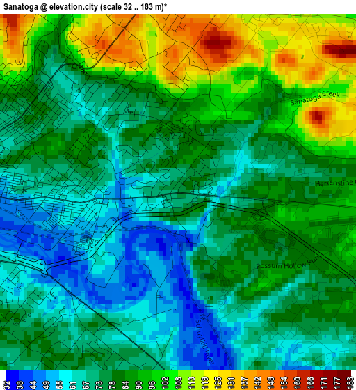
Below is the Elevation map of Sanatoga, which displays elevation range with different colors. Scale of the first map is from 32 to 183 m (105 to 600 ft) with average elevation of 81.4 meters (=267 ft) [note 1]
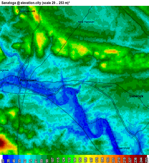
These maps also provides idea of topography and contour of this city, they are displayed at different zoom levels. More info about maps, scale and edge coordinates you can find below images.
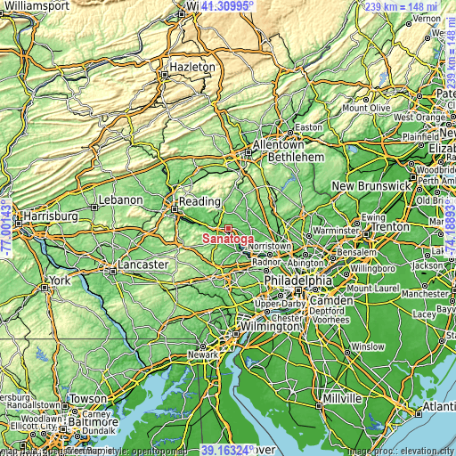
| \ | Map #1 | Map #2 | Topo.Map |
| Scale [m] | 32..183 m | 29..253 m | × |
| Scale [ft] | 105..600 ft | 95..830 ft | × |
| Average | 81.4 m = 267 ft | 87.6 m = 287 ft | × |
| Width | 7.46 km = 4.6 mi | 14.92 km = 9.3 mi | 238.7 km = 148.3 mi |
| Height | 7.46 km = 4.6 mi | 14.92 km = 9.3 mi | 238.7 km = 148.3 mi |
| ↑Max Latitude | 40.278635° | 40.312153° | 41.30995° |
| Latitude at center | 40.2451° | 40.2451° | 40.2451° |
| ↓Min Latitude | 40.211549° | 40.177981° | 39.16324° |
| ← Min Longitude | -75.639125° | -75.683071° | -77.00143° |
| Longitude center | -75.59518° | -75.59518° | -75.59518° |
| →Max Longitude | -75.551235° | -75.507289° | -74.18893° |
Nearby cities:
Cities around Sanatoga sort by population:
• Pottstown elevation 51 m
4.6 km,  270°
270°
• Limerick 90 m
6.4 km,  104°
104°
• Gilbertsville 106 m
8.4 km,  351°
351°
• Royersford 66 m
8.3 km,  144°
144°
• Boyertown 129 m
10.5 km,  340°
340°
• Stowe 62 m
7 km,  276°
276°
• Pottsgrove 83 m
2.6 km,  327°
327°
• Spring City 55 m
8.6 km,  152°
152°
• Halfway House 121 m
5.8 km,  315°
315°
• South Pottstown 45 m
4.8 km,  262°
262°
• Kenilworth 57 m
3.6 km,  245°
245°
• Schwenksville 53 m
11.2 km,  83°
83°
Multilingual:
 En español:
Sanatoga elevación 75 m.
 En France:
Sanatoga élévation 75 m.


Sources and notes:
- [note 1] Map square and city borders are not equal. Map elevation data is calculated only from area inside that square.
- [src 1] Elevation data from geonames database provided with same terms of usage.
- [src 2] The elevation map of Sanatoga is generated using elevation data from NASA's 3 arcsec (90m) resolution SRTM data.
- [src 3] Base (background) map © OpenStreetMap contributors tiles are generated by Geofabrik and OpenTopoMap.
Copyright & License:
This Sanatoga Elevation Map is licensed under CC BY-SA. You may reuse any part from this page, if you give a proper credit by linking to this URL:
 More info on terms of use page.