Pleasant Hills elevation
Pleasant Hills (Pennsylvania, Allegheny County), United States elevation is 374 meters and Pleasant Hills elevation in feet is 1227 ft above sea level [src 1]. Pleasant Hills is a populated place (feature code) with elevation that is 95 meters (312 ft) bigger than average city elevation in United States.
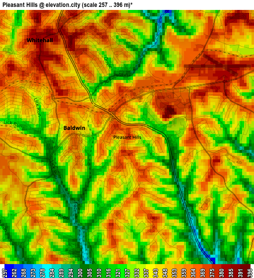
Below is the Elevation map of Pleasant Hills, which displays elevation range with different colors. Scale of the first map is from 257 to 396 m (843 to 1299 ft) with average elevation of 342.6 meters (=1124 ft) [note 1]
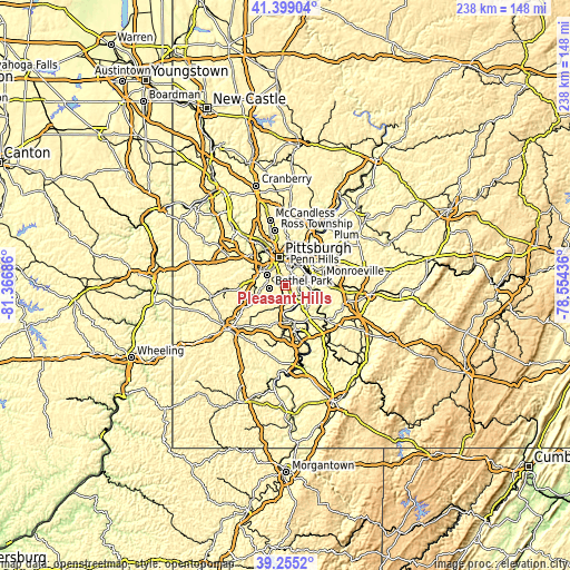
These maps also provides idea of topography and contour of this city, they are displayed at different zoom levels. More info about maps, scale and edge coordinates you can find below images.
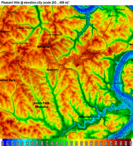
| \ | Map #1 | Map #2 | Topo.Map |
| Scale [m] | 257..396 m | 203..408 m | × |
| Scale [ft] | 843..1299 ft | 666..1339 ft | × |
| Average | 342.6 m = 1124 ft | 328 m = 1076 ft | × |
| Width | 7.45 km = 4.6 mi | 14.9 km = 9.3 mi | 238.4 km = 148.1 mi |
| Height | 7.45 km = 4.6 mi | 14.9 km = 9.3 mi | 238.4 km = 148.1 mi |
| ↑Max Latitude | 40.36912° | 40.402593° | 41.39904° |
| Latitude at center | 40.33563° | 40.33563° | 40.33563° |
| ↓Min Latitude | 40.302124° | 40.268601° | 39.2552° |
| ← Min Longitude | -80.004555° | -80.048501° | -81.36686° |
| Longitude center | -79.96061° | -79.96061° | -79.96061° |
| →Max Longitude | -79.916665° | -79.872719° | -78.55436° |
Nearby cities:
Cities around Pleasant Hills sort by population:
• Bethel Park elevation 365 m
6.7 km,  262°
262°
• Baldwin 358 m
1.6 km,  280°
280°
• Whitehall 387 m
3.8 km,  317°
317°
• South Park Township 293 m
5 km,  214°
214°
• Jefferson Hills 312 m
5.5 km,  153°
153°
• Brentwood 372 m
4.1 km,  342°
342°
• Castle Shannon 317 m
6.1 km,  301°
301°
• Wilson 239 m
6.5 km,  115°
115°
• Glassport 230 m
5.9 km,  101°
101°
• Port Vue 335 m
7.7 km,  89°
89°
• West Homestead 310 m
7.7 km,  32°
32°
• Dravosburg 226 m
6.5 km,  75°
75°
Multilingual:
 En español:
Pleasant Hills elevación 374 m.
 En France:
Pleasant Hills élévation 374 m.
 Auf Deutsch:
Pleasant Hills höhe über dem Meeresspiegel ist 374 m.

Sources and notes:
- [note 1] Map square and city borders are not equal. Map elevation data is calculated only from area inside that square.
- [src 1] Elevation data from geonames database provided with same terms of usage.
- [src 2] The elevation map of Pleasant Hills is generated using elevation data from NASA's 3 arcsec (90m) resolution SRTM data.
- [src 3] Base (background) map © OpenStreetMap contributors tiles are generated by Geofabrik and OpenTopoMap.
Copyright & License:
This Pleasant Hills Elevation Map is licensed under CC BY-SA. You may reuse any part from this page, if you give a proper credit by linking to this URL:
 More info on terms of use page.