Bethel Park elevation
Bethel Park (Pennsylvania, Allegheny County), United States elevation is 365 meters and Bethel Park elevation in feet is 1198 ft above sea level [src 1]. Bethel Park is a populated place (feature code) with elevation that is 86 meters (282 ft) bigger than average city elevation in United States.
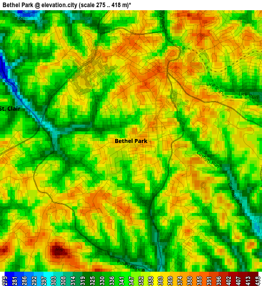
Below is the Elevation map of Bethel Park, which displays elevation range with different colors. Scale of the first map is from 275 to 418 m (902 to 1371 ft) with average elevation of 350.9 meters (=1151 ft) [note 1]
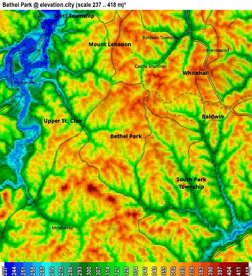
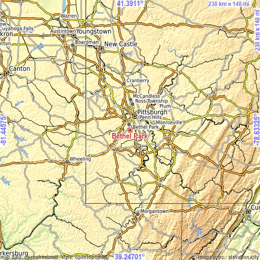
These maps also provides idea of topography and contour of this city, they are displayed at different zoom levels. More info about maps, scale and edge coordinates you can find below images.
| \ | Map #1 | Map #2 | Topo.Map |
| Scale [m] | 275..418 m | 237..418 m | × |
| Scale [ft] | 902..1371 ft | 778..1371 ft | × |
| Average | 350.9 m = 1151 ft | 335 m = 1099 ft | × |
| Width | 7.45 km = 4.6 mi | 14.9 km = 9.3 mi | 238.4 km = 148.1 mi |
| Height | 7.45 km = 4.6 mi | 14.9 km = 9.3 mi | 238.4 km = 148.1 mi |
| ↑Max Latitude | 40.361064° | 40.394541° | 41.3911° |
| Latitude at center | 40.32757° | 40.32757° | 40.32757° |
| ↓Min Latitude | 40.29406° | 40.260533° | 39.24701° |
| ← Min Longitude | -80.083445° | -80.127391° | -81.44575° |
| Longitude center | -80.0395° | -80.0395° | -80.0395° |
| →Max Longitude | -79.995555° | -79.951609° | -78.63325° |
Nearby cities:
Cities around Bethel Park sort by population:
• Mount Lebanon elevation 323 m
3.2 km,  344°
344°
• Baldwin 358 m
5.3 km,  77°
77°
• Upper Saint Clair 332 m
3.8 km,  283°
283°
• Whitehall 387 m
5.6 km,  47°
47°
• South Park Township 293 m
5 km,  129°
129°
• Brentwood 372 m
7.3 km, 48°
• Pleasant Hills 374 m
6.7 km, 82°
• Castle Shannon 317 m
4.4 km,  19°
19°
• Bridgeville 263 m
6.8 km,  298°
298°
• Bryn Mawr 352 m
4.8 km,  236°
236°
• McMurray 310 m
6.7 km,  214°
214°
• Thompsonville 289 m
7.1 km,  234°
234°
Multilingual:
 En español:
Bethel Park elevación 365 m.
 En France:
Bethel Park élévation 365 m.
 Auf Deutsch:
Bethel Park höhe über dem Meeresspiegel ist 365 m.

Sources and notes:
- [note 1] Map square and city borders are not equal. Map elevation data is calculated only from area inside that square.
- [src 1] Elevation data from geonames database provided with same terms of usage.
- [src 2] The elevation map of Bethel Park is generated using elevation data from NASA's 3 arcsec (90m) resolution SRTM data.
- [src 3] Base (background) map © OpenStreetMap contributors tiles are generated by Geofabrik and OpenTopoMap.
Copyright & License:
This Bethel Park Elevation Map is licensed under CC BY-SA. You may reuse any part from this page, if you give a proper credit by linking to this URL:
 More info on terms of use page.