Montgomeryville elevation
Montgomeryville (Pennsylvania, Montgomery County), United States elevation is 141 meters and Montgomeryville elevation in feet is 463 ft above sea level [src 1]. Montgomeryville is a populated place (feature code) with elevation that is 138 meters (453 ft) smaller than average city elevation in United States.
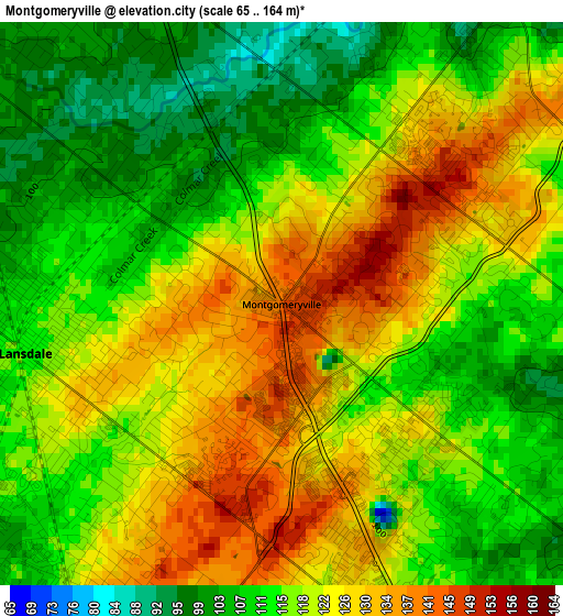
Below is the Elevation map of Montgomeryville, which displays elevation range with different colors. Scale of the first map is from 65 to 164 m (213 to 538 ft) with average elevation of 118.3 meters (=388 ft) [note 1]
These maps also provides idea of topography and contour of this city, they are displayed at different zoom levels. More info about maps, scale and edge coordinates you can find below images.
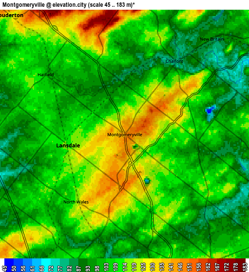
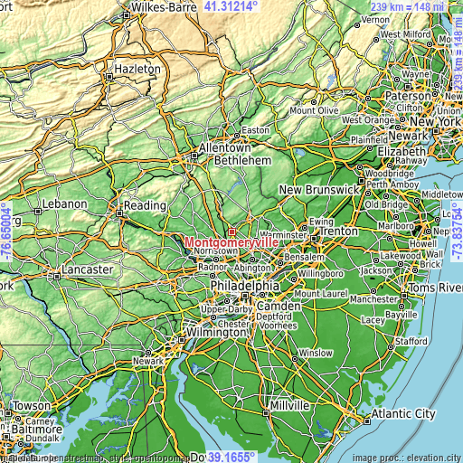
| \ | Map #1 | Map #2 | Topo.Map |
| Scale [m] | 65..164 m | 45..183 m | × |
| Scale [ft] | 213..538 ft | 148..600 ft | × |
| Average | 118.3 m = 388 ft | 107.6 m = 353 ft | × |
| Width | 7.46 km = 4.6 mi | 14.92 km = 9.3 mi | 238.7 km = 148.3 mi |
| Height | 7.46 km = 4.6 mi | 14.92 km = 9.3 mi | 238.7 km = 148.3 mi |
| ↑Max Latitude | 40.280864° | 40.31438° | 41.31214° |
| Latitude at center | 40.24733° | 40.24733° | 40.24733° |
| ↓Min Latitude | 40.21378° | 40.180213° | 39.1655° |
| ← Min Longitude | -75.287735° | -75.331681° | -76.65004° |
| Longitude center | -75.24379° | -75.24379° | -75.24379° |
| →Max Longitude | -75.199845° | -75.155899° | -73.83754° |
Nearby cities:
Cities around Montgomeryville sort by population:
• Lansdale elevation 111 m
3.5 km,  259°
259°
• Kulpsville 88 m
7.9 km,  266°
266°
• Souderton 126 m
10 km,  316°
316°
• Maple Glen 118 m
9.3 km,  144°
144°
• Ambler 69 m
10.5 km,  169°
169°
• Blue Bell 112 m
10.7 km,  190°
190°
• Chalfont 87 m
5.4 km,  32°
32°
• Spring House 92 m
7 km, 168°
• Brittany Farms-Highlands 126 m
3.5 km,  46°
46°
• Hatfield 103 m
5.9 km,  307°
307°
• North Wales 115 m
5 km,  215°
215°
• New Britain 93 m
7.8 km,  42°
42°
Multilingual:
 En español:
Montgomeryville elevación 141 m.
 En France:
Montgomeryville élévation 141 m.
 Auf Deutsch:
Montgomeryville höhe über dem Meeresspiegel ist 141 m.

Sources and notes:
- [note 1] Map square and city borders are not equal. Map elevation data is calculated only from area inside that square.
- [src 1] Elevation data from geonames database provided with same terms of usage.
- [src 2] The elevation map of Montgomeryville is generated using elevation data from NASA's 3 arcsec (90m) resolution SRTM data.
- [src 3] Base (background) map © OpenStreetMap contributors tiles are generated by Geofabrik and OpenTopoMap.
Copyright & License:
This Montgomeryville Elevation Map is licensed under CC BY-SA. You may reuse any part from this page, if you give a proper credit by linking to this URL:
 More info on terms of use page.