Mill Hall elevation
Mill Hall (Pennsylvania, Clinton County), United States elevation is 176 meters and Mill Hall elevation in feet is 577 ft above sea level [src 1]. Mill Hall is a populated place (feature code) with elevation that is 103 meters (338 ft) smaller than average city elevation in United States.
Below is the Elevation map of Mill Hall, which displays elevation range with different colors. Scale of the first map is from 153 to 524 m (502 to 1719 ft) with average elevation of 248.9 meters (=817 ft) [note 1]
These maps also provides idea of topography and contour of this city, they are displayed at different zoom levels. More info about maps, scale and edge coordinates you can find below images.
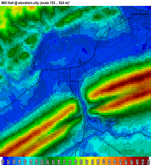
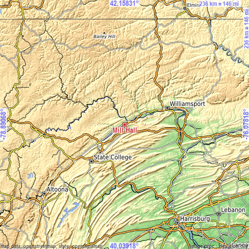
| \ | Map #1 | Topo.Map |
| Scale [m] | 153..524 m | × |
| Scale [ft] | 502..1719 ft | × |
| Average | 248.9 m = 817 ft | × |
| Width | 7.36 km = 4.6 mi | 235.6 km = 146.4 mi |
| Height | 7.36 km = 4.6 mi | 235.6 km = 146.4 mi |
| ↑Max Latitude | 41.140394° | 42.15831° |
| Latitude at center | 41.10729° | 41.10729° |
| ↓Min Latitude | 41.07417° | 40.03918° |
| ← Min Longitude | -77.528375° | -78.89068° |
| Longitude center | -77.48443° | -77.48443° |
| →Max Longitude | -77.440485° | -76.07818° |
Nearby cities:
Cities around Mill Hall sort by population:
• Lock Haven elevation 171 m
4.6 km,  43°
43°
• Bellefonte 240 m
32.8 km,  228°
228°
• Jersey Shore 181 m
21.2 km,  60°
60°
• Pleasant Gap 300 m
34.5 km,  219°
219°
• Zion 311 m
27.3 km, 218°
• Avis 180 m
16.7 km, 58°
• Dunnstown 198 m
6.8 km,  50°
50°
• Flemington 199 m
2.4 km,  26°
26°
• Centre Hall 406 m
33.5 km,  210°
210°
• Renovo 203 m
33 km,  317°
317°
• Castanea 180 m
5 km,  67°
67°
• Milesburg 214 m
31.2 km, 233°
Multilingual:
 En español:
Mill Hall elevación 176 m.
 En France:
Mill Hall élévation 176 m.
 Auf Deutsch:
Mill Hall höhe über dem Meeresspiegel ist 176 m.

Sources and notes:
- [note 1] Map square and city borders are not equal. Map elevation data is calculated only from area inside that square.
- [src 1] Elevation data from geonames database provided with same terms of usage.
- [src 2] The elevation map of Mill Hall is generated using elevation data from NASA's 3 arcsec (90m) resolution SRTM data.
- [src 3] Base (background) map © OpenStreetMap contributors tiles are generated by Geofabrik and OpenTopoMap.
Copyright & License:
This Mill Hall Elevation Map is licensed under CC BY-SA. You may reuse any part from this page, if you give a proper credit by linking to this URL:
 More info on terms of use page.