Mayfield elevation
Mayfield (Pennsylvania, Westmoreland County), United States elevation is 332 meters and Mayfield elevation in feet is 1089 ft above sea level [src 1]. Mayfield is a populated place (feature code) with elevation that is 53 meters (174 ft) bigger than average city elevation in United States.
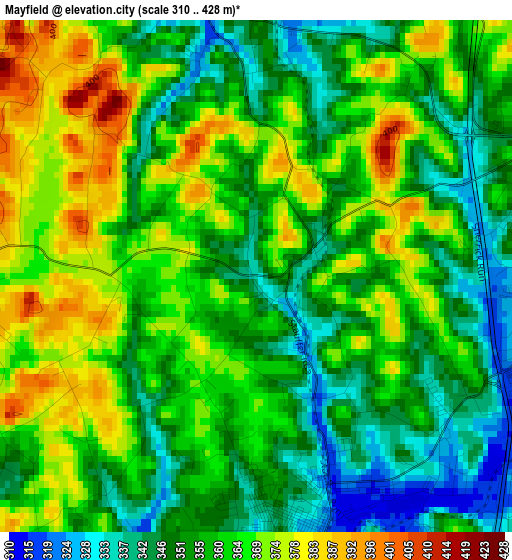
Below is the Elevation map of Mayfield, which displays elevation range with different colors. Scale of the first map is from 310 to 428 m (1017 to 1404 ft) with average elevation of 358.9 meters (=1177 ft) [note 1]
These maps also provides idea of topography and contour of this city, they are displayed at different zoom levels. More info about maps, scale and edge coordinates you can find below images.
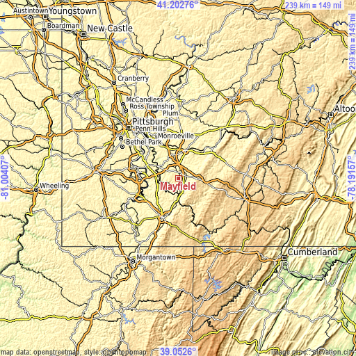
| \ | Map #1 | Topo.Map |
| Scale [m] | 310..428 m | × |
| Scale [ft] | 1017..1404 ft | × |
| Average | 358.9 m = 1177 ft | × |
| Width | 7.47 km = 4.6 mi | 239.1 km = 148.6 mi |
| Height | 7.47 km = 4.6 mi | 239.1 km = 148.6 mi |
| ↑Max Latitude | 40.169769° | 41.20276° |
| Latitude at center | 40.13618° | 40.13618° |
| ↓Min Latitude | 40.102575° | 39.0526° |
| ← Min Longitude | -79.641765° | -81.00407° |
| Longitude center | -79.59782° | -79.59782° |
| →Max Longitude | -79.553875° | -78.19157° |
Nearby cities:
Cities around Mayfield sort by population:
• Connellsville elevation 283 m
13.2 km,  176°
176°
• Mount Pleasant 351 m
5 km,  73°
73°
• Scottdale 314 m
4.1 km,  166°
166°
• Youngwood 291 m
11.7 km,  8°
8°
• West Newton 236 m
16.5 km,  299°
299°
• New Stanton 296 m
9.3 km,  353°
353°
• South Greensburg 325 m
16.4 km,  15°
15°
• South Connellsville 320 m
15.5 km, 176°
• Perryopolis 307 m
14.1 km,  247°
247°
• Calumet 305 m
12.7 km,  49°
49°
• Collinsburg 236 m
17.5 km, 304°
• Bear Rocks 610 m
11.7 km,  97°
97°
Multilingual:
 En español:
Mayfield elevación 332 m.
 En France:
Mayfield élévation 332 m.
 Auf Deutsch:
Mayfield höhe über dem Meeresspiegel ist 332 m.

Sources and notes:
- [note 1] Map square and city borders are not equal. Map elevation data is calculated only from area inside that square.
- [src 1] Elevation data from geonames database provided with same terms of usage.
- [src 2] The elevation map of Mayfield is generated using elevation data from NASA's 3 arcsec (90m) resolution SRTM data.
- [src 3] Base (background) map © OpenStreetMap contributors tiles are generated by Geofabrik and OpenTopoMap.
Copyright & License:
This Mayfield Elevation Map is licensed under CC BY-SA. You may reuse any part from this page, if you give a proper credit by linking to this URL:
 More info on terms of use page.