Perryopolis elevation
Perryopolis (Pennsylvania, Fayette County), United States elevation is 307 meters and Perryopolis elevation in feet is 1007 ft above sea level [src 1]. Perryopolis is a populated place (feature code) with elevation that is 28 meters (92 ft) bigger than average city elevation in United States.
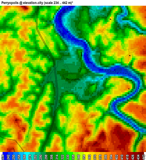
Below is the Elevation map of Perryopolis, which displays elevation range with different colors. Scale of the first map is from 234 to 442 m (768 to 1450 ft) with average elevation of 335 meters (=1099 ft) [note 1]
These maps also provides idea of topography and contour of this city, they are displayed at different zoom levels. More info about maps, scale and edge coordinates you can find below images.
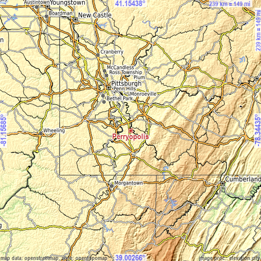
| \ | Map #1 | Topo.Map |
| Scale [m] | 234..442 m | × |
| Scale [ft] | 768..1450 ft | × |
| Average | 335 m = 1099 ft | × |
| Width | 7.48 km = 4.6 mi | 239.2 km = 148.6 mi |
| Height | 7.48 km = 4.6 mi | 239.2 km = 148.6 mi |
| ↑Max Latitude | 40.120633° | 41.15438° |
| Latitude at center | 40.08702° | 40.08702° |
| ↓Min Latitude | 40.053391° | 39.00266° |
| ← Min Longitude | -79.794545° | -81.15685° |
| Longitude center | -79.7506° | -79.7506° |
| →Max Longitude | -79.706655° | -78.34435° |
Nearby cities:
Cities around Perryopolis sort by population:
• Monessen elevation 340 m
13.5 km,  300°
300°
• California 241 m
12.2 km,  258°
258°
• Donora 247 m
13.2 km,  316°
316°
• Charleroi 241 m
13.8 km,  294°
294°
• West Newton 236 m
13.7 km,  354°
354°
• Brownsville 247 m
13.4 km,  238°
238°
• Lynnwood-Pricedale 283 m
9.8 km, 299°
• North Belle Vernon 275 m
11 km, 295°
• Fellsburg 339 m
12.4 km,  329°
329°
• Fairhope 287 m
8.1 km, 291°
• Speers 252 m
11.7 km, 290°
• Belle Vernon 238 m
10.7 km, 293°
Multilingual:
 En español:
Perryopolis elevación 307 m.
 En France:
Perryopolis élévation 307 m.
 Auf Deutsch:
Perryopolis höhe über dem Meeresspiegel ist 307 m.

Sources and notes:
- [note 1] Map square and city borders are not equal. Map elevation data is calculated only from area inside that square.
- [src 1] Elevation data from geonames database provided with same terms of usage.
- [src 2] The elevation map of Perryopolis is generated using elevation data from NASA's 3 arcsec (90m) resolution SRTM data.
- [src 3] Base (background) map © OpenStreetMap contributors tiles are generated by Geofabrik and OpenTopoMap.
Copyright & License:
This Perryopolis Elevation Map is licensed under CC BY-SA. You may reuse any part from this page, if you give a proper credit by linking to this URL:
 More info on terms of use page.