Hometown elevation
Hometown (Pennsylvania, Schuylkill County), United States elevation is 347 meters and Hometown elevation in feet is 1138 ft above sea level [src 1]. Hometown is a populated place (feature code) with elevation that is 68 meters (223 ft) bigger than average city elevation in United States.
Below is the Elevation map of Hometown, which displays elevation range with different colors. Scale of the first map is from 242 to 531 m (794 to 1742 ft) with average elevation of 373 meters (=1224 ft) [note 1]
These maps also provides idea of topography and contour of this city, they are displayed at different zoom levels. More info about maps, scale and edge coordinates you can find below images.
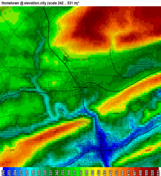
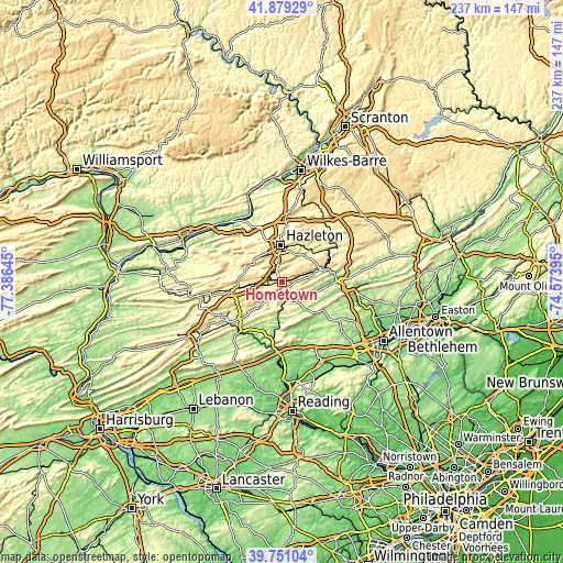
| \ | Map #1 | Topo.Map |
| Scale [m] | 242..531 m | × |
| Scale [ft] | 794..1742 ft | × |
| Average | 373 m = 1224 ft | × |
| Width | 7.4 km = 4.6 mi | 236.6 km = 147 mi |
| Height | 7.4 km = 4.6 mi | 236.6 km = 147 mi |
| ↑Max Latitude | 40.856946° | 41.87929° |
| Latitude at center | 40.8237° | 40.8237° |
| ↓Min Latitude | 40.790437° | 39.75104° |
| ← Min Longitude | -76.024145° | -77.38645° |
| Longitude center | -75.9802° | -75.9802° |
| →Max Longitude | -75.936255° | -74.57395° |
Nearby cities:
Cities around Hometown sort by population:
• Hazleton elevation 505 m
15 km,  1°
1°
• Tamaqua 246 m
3.1 km,  162°
162°
• West Hazleton 518 m
15.1 km,  354°
354°
• Mahanoy City 374 m
13.6 km,  264°
264°
• Lansford 351 m
8.3 km,  83°
83°
• Nesquehoning 256 m
14.9 km,  72°
72°
• Summit Hill 464 m
9.2 km,  89°
89°
• Weatherly 344 m
18.2 km,  43°
43°
• McAdoo 535 m
8.7 km, 353°
• Coaldale 320 m
6.2 km, 90°
• Harleigh 473 m
17.5 km, 2°
• New Philadelphia 213 m
16.3 km,  224°
224°
Multilingual:
 En español:
Hometown elevación 347 m.
 En France:
Hometown élévation 347 m.
 Auf Deutsch:
Hometown höhe über dem Meeresspiegel ist 347 m.

Sources and notes:
- [note 1] Map square and city borders are not equal. Map elevation data is calculated only from area inside that square.
- [src 1] Elevation data from geonames database provided with same terms of usage.
- [src 2] The elevation map of Hometown is generated using elevation data from NASA's 3 arcsec (90m) resolution SRTM data.
- [src 3] Base (background) map © OpenStreetMap contributors tiles are generated by Geofabrik and OpenTopoMap.
Copyright & License:
This Hometown Elevation Map is licensed under CC BY-SA. You may reuse any part from this page, if you give a proper credit by linking to this URL:
 More info on terms of use page.