Hazleton elevation
Hazleton (Pennsylvania, Luzerne County), United States elevation is 505 meters and Hazleton elevation in feet is 1657 ft above sea level [src 1]. Hazleton is a populated place (feature code) with elevation that is 226 meters (741 ft) bigger than average city elevation in United States.
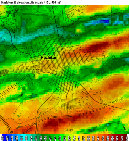
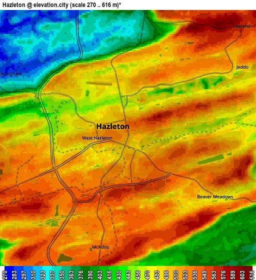
Below is the Elevation map of Hazleton, which displays elevation range with different colors. Scale of the first map is from 415 to 586 m (1362 to 1923 ft) with average elevation of 508.2 meters (=1667 ft) [note 1]
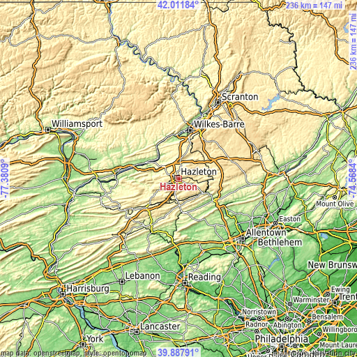
These maps also provides idea of topography and contour of this city, they are displayed at different zoom levels. More info about maps, scale and edge coordinates you can find below images.
| \ | Map #1 | Map #2 | Topo.Map |
| Scale [m] | 415..586 m | 270..616 m | × |
| Scale [ft] | 1362..1923 ft | 886..2021 ft | × |
| Average | 508.2 m = 1667 ft | 482.2 m = 1582 ft | × |
| Width | 7.38 km = 4.6 mi | 14.76 km = 9.2 mi | 236.2 km = 146.8 mi |
| Height | 7.38 km = 4.6 mi | 14.76 km = 9.2 mi | 236.2 km = 146.8 mi |
| ↑Max Latitude | 40.991599° | 41.02476° | 42.01184° |
| Latitude at center | 40.95842° | 40.95842° | 40.95842° |
| ↓Min Latitude | 40.925225° | 40.892013° | 39.88791° |
| ← Min Longitude | -76.018595° | -76.062541° | -77.3809° |
| Longitude center | -75.97465° | -75.97465° | -75.97465° |
| →Max Longitude | -75.930705° | -75.886759° | -74.5684° |
Nearby cities:
Cities around Hazleton sort by population:
• West Hazleton elevation 518 m
1.8 km,  270°
270°
• Lansford 351 m
16.1 km,  151°
151°
• Freeland 571 m
9.2 km,  45°
45°
• Summit Hill 464 m
17.2 km, 149°
• Weatherly 344 m
12.3 km,  98°
98°
• McAdoo 535 m
6.5 km,  192°
192°
• Coaldale 320 m
16.1 km,  159°
159°
• Beech Mountain Lakes 337 m
9.8 km,  19°
19°
• Conyngham 297 m
7.8 km,  298°
298°
• Oakdale 493 m
5.9 km, 50°
• Hometown 347 m
15 km,  181°
181°
• Harleigh 473 m
2.5 km,  6°
6°
Multilingual:
 En español:
Hazleton elevación 505 m.
 En France:
Hazleton élévation 505 m.
 Auf Deutsch:
Hazleton höhe über dem Meeresspiegel ist 505 m.

Sources and notes:
- [note 1] Map square and city borders are not equal. Map elevation data is calculated only from area inside that square.
- [src 1] Elevation data from geonames database provided with same terms of usage.
- [src 2] The elevation map of Hazleton is generated using elevation data from NASA's 3 arcsec (90m) resolution SRTM data.
- [src 3] Base (background) map © OpenStreetMap contributors tiles are generated by Geofabrik and OpenTopoMap.
Copyright & License:
This Hazleton Elevation Map is licensed under CC BY-SA. You may reuse any part from this page, if you give a proper credit by linking to this URL:
 More info on terms of use page.