Hawley elevation
Hawley (Pennsylvania, Wayne County), United States elevation is 279 meters and Hawley elevation in feet is 915 ft above sea level [src 1]. Hawley is a populated place (feature code) with elevation that is 0 meters (0 ft) bigger than average city elevation in United States.
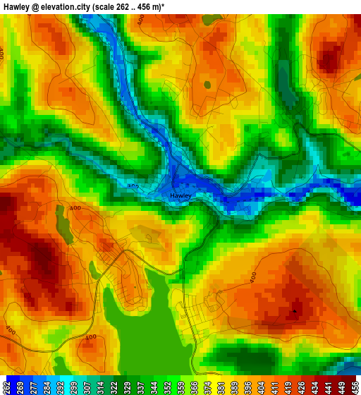
Below is the Elevation map of Hawley, which displays elevation range with different colors. Scale of the first map is from 262 to 456 m (860 to 1496 ft) with average elevation of 371.3 meters (=1218 ft) [note 1]
These maps also provides idea of topography and contour of this city, they are displayed at different zoom levels. More info about maps, scale and edge coordinates you can find below images.
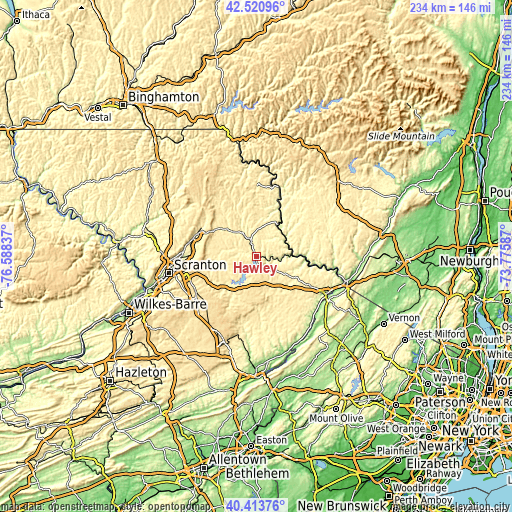
| \ | Map #1 | Topo.Map |
| Scale [m] | 262..456 m | × |
| Scale [ft] | 860..1496 ft | × |
| Average | 371.3 m = 1218 ft | × |
| Width | 7.32 km = 4.5 mi | 234.3 km = 145.6 mi |
| Height | 7.32 km = 4.5 mi | 234.3 km = 145.6 mi |
| ↑Max Latitude | 41.508837° | 42.52096° |
| Latitude at center | 41.47592° | 41.47592° |
| ↓Min Latitude | 41.442986° | 40.41376° |
| ← Min Longitude | -75.226065° | -76.58837° |
| Longitude center | -75.18212° | -75.18212° |
| →Max Longitude | -75.138175° | -73.77587° |
Nearby cities:
Cities around Hawley sort by population:
• Carbondale elevation 327 m
28.8 km,  292°
292°
• Archbald 289 m
29.6 km,  274°
274°
• Honesdale 301 m
12.9 km,  330°
330°
• Hemlock Farms 424 m
20.6 km,  143°
143°
• The Hideout 413 m
15.2 km,  249°
249°
• Gold Key Lake 424 m
27.8 km,  132°
132°
• Mount Cobb 507 m
26.8 km, 254°
• Sunrise Lake 449 m
25.8 km, 135°
• Conashaugh Lakes 444 m
24.8 km, 139°
• Waymart 429 m
22.1 km,  301°
301°
• Wallenpaupack Lake Estates 423 m
11.5 km,  221°
221°
• Simpson 350 m
28.3 km, 297°
Multilingual:
 En español:
Hawley elevación 279 m.
 En France:
Hawley élévation 279 m.


Sources and notes:
- [note 1] Map square and city borders are not equal. Map elevation data is calculated only from area inside that square.
- [src 1] Elevation data from geonames database provided with same terms of usage.
- [src 2] The elevation map of Hawley is generated using elevation data from NASA's 3 arcsec (90m) resolution SRTM data.
- [src 3] Base (background) map © OpenStreetMap contributors tiles are generated by Geofabrik and OpenTopoMap.
Copyright & License:
This Hawley Elevation Map is licensed under CC BY-SA. You may reuse any part from this page, if you give a proper credit by linking to this URL:
 More info on terms of use page.