Conashaugh Lakes elevation
Conashaugh Lakes (Pennsylvania, Pike County), United States elevation is 444 meters and Conashaugh Lakes elevation in feet is 1457 ft above sea level [src 1]. Conashaugh Lakes is a populated place (feature code) with elevation that is 165 meters (541 ft) bigger than average city elevation in United States.
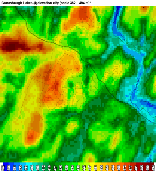
Below is the Elevation map of Conashaugh Lakes, which displays elevation range with different colors. Scale of the first map is from 382 to 494 m (1253 to 1621 ft) with average elevation of 434.2 meters (=1425 ft) [note 1]
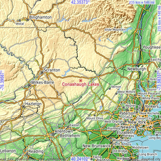
These maps also provides idea of topography and contour of this city, they are displayed at different zoom levels. More info about maps, scale and edge coordinates you can find below images.
| \ | Map #1 | Topo.Map |
| Scale [m] | 382..494 m | × |
| Scale [ft] | 1253..1621 ft | × |
| Average | 434.2 m = 1425 ft | × |
| Width | 7.34 km = 4.6 mi | 234.9 km = 146 mi |
| Height | 7.34 km = 4.6 mi | 234.9 km = 146 mi |
| ↑Max Latitude | 41.338933° | 42.35373° |
| Latitude at center | 41.30593° | 41.30593° |
| ↓Min Latitude | 41.27291° | 40.24102° |
| ← Min Longitude | -75.033565° | -76.39587° |
| Longitude center | -74.98962° | -74.98962° |
| →Max Longitude | -74.945675° | -73.58337° |
Nearby cities:
Cities around Conashaugh Lakes sort by population:
• Saw Creek elevation 230 m
22.1 km,  193°
193°
• Hemlock Farms 424 m
4.6 km,  300°
300°
• Pine Ridge 393 m
17.8 km,  180°
180°
• Matamoras 134 m
25.2 km,  73°
73°
• Gold Key Lake 424 m
4.3 km,  90°
90°
• Sunrise Lake 449 m
2 km,  77°
77°
• Birchwood Lakes 354 m
8.2 km,  133°
133°
• Wallenpaupack Lake Estates 423 m
25.9 km,  293°
293°
• Crandon Lakes 268 m
23.8 km,  148°
148°
• Hawley 279 m
24.8 km,  319°
319°
• Pocono Ranch Lands 293 m
16 km,  168°
168°
• Milford 154 m
15.7 km, 83°
Multilingual:
 En español:
Conashaugh Lakes elevación 444 m.
 En France:
Conashaugh Lakes élévation 444 m.
 Auf Deutsch:
Conashaugh Lakes höhe über dem Meeresspiegel ist 444 m.

Sources and notes:
- [note 1] Map square and city borders are not equal. Map elevation data is calculated only from area inside that square.
- [src 1] Elevation data from geonames database provided with same terms of usage.
- [src 2] The elevation map of Conashaugh Lakes is generated using elevation data from NASA's 3 arcsec (90m) resolution SRTM data.
- [src 3] Base (background) map © OpenStreetMap contributors tiles are generated by Geofabrik and OpenTopoMap.
Copyright & License:
This Conashaugh Lakes Elevation Map is licensed under CC BY-SA. You may reuse any part from this page, if you give a proper credit by linking to this URL:
 More info on terms of use page.