Hatboro elevation
Hatboro (Pennsylvania, Montgomery County), United States elevation is 71 meters and Hatboro elevation in feet is 233 ft above sea level [src 1]. Hatboro is a populated place (feature code) with elevation that is 208 meters (682 ft) smaller than average city elevation in United States.
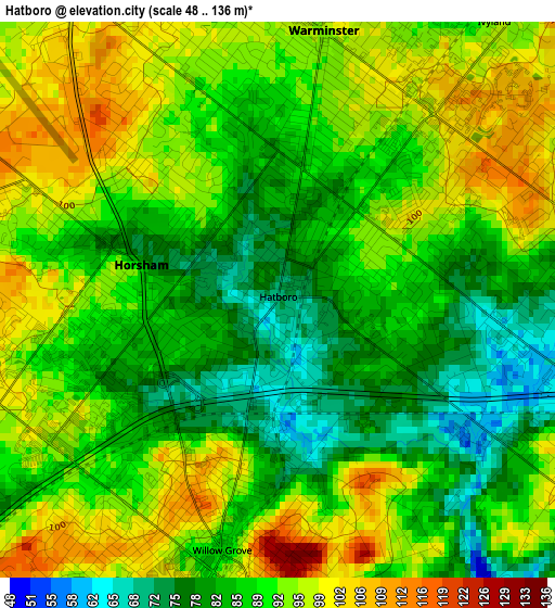
Below is the Elevation map of Hatboro, which displays elevation range with different colors. Scale of the first map is from 48 to 136 m (157 to 446 ft) with average elevation of 89.5 meters (=294 ft) [note 1]
These maps also provides idea of topography and contour of this city, they are displayed at different zoom levels. More info about maps, scale and edge coordinates you can find below images.
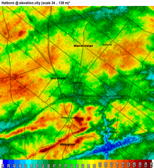
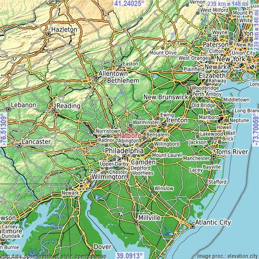
| \ | Map #1 | Map #2 | Topo.Map |
| Scale [m] | 48..136 m | 34..138 m | × |
| Scale [ft] | 157..446 ft | 112..453 ft | × |
| Average | 89.5 m = 294 ft | 87.1 m = 286 ft | × |
| Width | 7.47 km = 4.6 mi | 14.93 km = 9.3 mi | 238.9 km = 148.4 mi |
| Height | 7.47 km = 4.6 mi | 14.93 km = 9.3 mi | 238.9 km = 148.4 mi |
| ↑Max Latitude | 40.20785° | 40.241403° | 41.24025° |
| Latitude at center | 40.17428° | 40.17428° | 40.17428° |
| ↓Min Latitude | 40.140694° | 40.107091° | 39.0913° |
| ← Min Longitude | -75.150785° | -75.194731° | -76.51309° |
| Longitude center | -75.10684° | -75.10684° | -75.10684° |
| →Max Longitude | -75.062895° | -75.018949° | -73.70059° |
Nearby cities:
Cities around Hatboro sort by population:
• Willow Grove elevation 87 m
3.5 km,  192°
192°
• Horsham 78 m
1.9 km,  284°
284°
• Glenside 85 m
8.9 km,  205°
205°
• Maple Glen 118 m
6.3 km, 275°
• Richboro 82 m
9.3 km,  60°
60°
• Oreland 83 m
8.6 km,  224°
224°
• Dresher 64 m
6.3 km,  233°
233°
• Jenkintown 104 m
8.8 km, 190°
• Churchville 66 m
7.6 km,  79°
79°
• Warminster Heights 98 m
2.6 km, 56°
• Bryn Athyn 77 m
5.8 km,  144°
144°
• Ivyland 94 m
4.7 km,  37°
37°
Multilingual:
 En español:
Hatboro elevación 71 m.
 En France:
Hatboro élévation 71 m.


Sources and notes:
- [note 1] Map square and city borders are not equal. Map elevation data is calculated only from area inside that square.
- [src 1] Elevation data from geonames database provided with same terms of usage.
- [src 2] The elevation map of Hatboro is generated using elevation data from NASA's 3 arcsec (90m) resolution SRTM data.
- [src 3] Base (background) map © OpenStreetMap contributors tiles are generated by Geofabrik and OpenTopoMap.
Copyright & License:
This Hatboro Elevation Map is licensed under CC BY-SA. You may reuse any part from this page, if you give a proper credit by linking to this URL:
 More info on terms of use page.