Fernway elevation
Fernway (Pennsylvania, Butler County), United States elevation is 317 meters and Fernway elevation in feet is 1040 ft above sea level [src 1]. Fernway is a populated place (feature code) with elevation that is 38 meters (125 ft) bigger than average city elevation in United States.
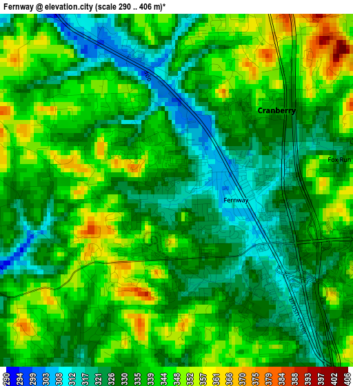
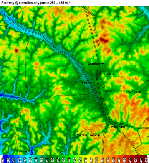
Below is the Elevation map of Fernway, which displays elevation range with different colors. Scale of the first map is from 290 to 406 m (951 to 1332 ft) with average elevation of 335.2 meters (=1100 ft) [note 1]
These maps also provides idea of topography and contour of this city, they are displayed at different zoom levels. More info about maps, scale and edge coordinates you can find below images.
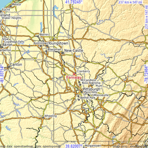
| \ | Map #1 | Map #2 | Topo.Map |
| Scale [m] | 290..406 m | 259..435 m | × |
| Scale [ft] | 951..1332 ft | 850..1427 ft | × |
| Average | 335.2 m = 1100 ft | 341 m = 1119 ft | × |
| Width | 7.41 km = 4.6 mi | 14.82 km = 9.2 mi | 237.1 km = 147.3 mi |
| Height | 7.41 km = 4.6 mi | 14.82 km = 9.2 mi | 237.1 km = 147.3 mi |
| ↑Max Latitude | 40.728101° | 40.761395° | 41.75245° |
| Latitude at center | 40.69479° | 40.69479° | 40.69479° |
| ↓Min Latitude | 40.661463° | 40.628119° | 39.62007° |
| ← Min Longitude | -80.174835° | -80.218781° | -81.53714° |
| Longitude center | -80.13089° | -80.13089° | -80.13089° |
| →Max Longitude | -80.086945° | -80.042999° | -78.72464° |
Nearby cities:
Cities around Fernway sort by population:
• Cranberry Township elevation 315 m
2.3 km,  118°
118°
• Aliquippa 225 m
11.2 km,  234°
234°
• Monaca 224 m
11.9 km,  265°
265°
• Baden 237 m
10.6 km, 231°
• Zelienople 290 m
11.1 km,  357°
357°
• Fox Run 333 m
4.1 km,  78°
78°
• Seven Fields 331 m
5.8 km,  93°
93°
• Conway 226 m
9.9 km,  246°
246°
• Evans City 285 m
10.1 km,  34°
34°
• Mars 316 m
10 km, 89°
• Freedom 237 m
10.2 km,  264°
264°
• Bradford Woods 374 m
7.6 km,  146°
146°
Multilingual:
 En español:
Fernway elevación 317 m.
 En France:
Fernway élévation 317 m.


Sources and notes:
- [note 1] Map square and city borders are not equal. Map elevation data is calculated only from area inside that square.
- [src 1] Elevation data from geonames database provided with same terms of usage.
- [src 2] The elevation map of Fernway is generated using elevation data from NASA's 3 arcsec (90m) resolution SRTM data.
- [src 3] Base (background) map © OpenStreetMap contributors tiles are generated by Geofabrik and OpenTopoMap.
Copyright & License:
This Fernway Elevation Map is licensed under CC BY-SA. You may reuse any part from this page, if you give a proper credit by linking to this URL:
 More info on terms of use page.