Corry elevation
Corry (Pennsylvania, Erie County), United States elevation is 437 meters and Corry elevation in feet is 1434 ft above sea level [src 1]. Corry is a populated place (feature code) with elevation that is 158 meters (518 ft) bigger than average city elevation in United States.
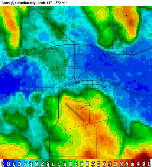
Below is the Elevation map of Corry, which displays elevation range with different colors. Scale of the first map is from 417 to 572 m (1368 to 1877 ft) with average elevation of 465.3 meters (=1527 ft) [note 1]
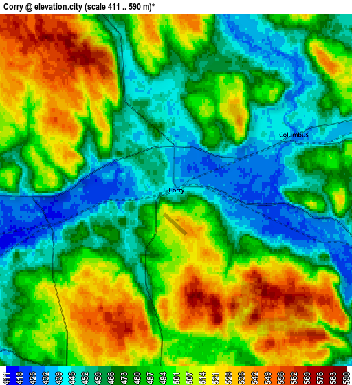
These maps also provides idea of topography and contour of this city, they are displayed at different zoom levels. More info about maps, scale and edge coordinates you can find below images.
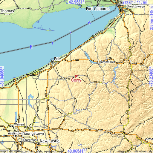
| \ | Map #1 | Map #2 | Topo.Map |
| Scale [m] | 417..572 m | 411..590 m | × |
| Scale [ft] | 1368..1877 ft | 1348..1936 ft | × |
| Average | 465.3 m = 1527 ft | 486.3 m = 1595 ft | × |
| Width | 7.27 km = 4.5 mi | 14.54 km = 9 mi | 232.7 km = 144.6 mi |
| Height | 7.27 km = 4.5 mi | 14.54 km = 9 mi | 232.7 km = 144.6 mi |
| ↑Max Latitude | 41.95302° | 41.985694° | 42.9581° |
| Latitude at center | 41.92033° | 41.92033° | 41.92033° |
| ↓Min Latitude | 41.887623° | 41.854899° | 40.86541° |
| ← Min Longitude | -79.684275° | -79.728221° | -81.04658° |
| Longitude center | -79.64033° | -79.64033° | -79.64033° |
| →Max Longitude | -79.596385° | -79.552439° | -78.23408° |
Nearby cities:
Cities around Corry sort by population:
• Titusville elevation 368 m
32.7 km,  184°
184°
• North East 244 m
36.5 km,  334°
334°
• Union City 386 m
17.1 km,  262°
262°
• Lakewood 409 m
32.6 km,  51°
51°
• Cambridge Springs 355 m
36.8 km,  249°
249°
• Jamestown West 458 m
35.1 km,  57°
57°
• Clymer 444 m
11.2 km,  4°
4°
• Mayville 444 m
38.8 km,  16°
16°
• Youngsville 366 m
27.7 km,  105°
105°
• Waterford 372 m
28.6 km,  275°
275°
• Kiantone 465 m
38.3 km,  72°
72°
• Celoron 407 m
36.2 km, 54°
Multilingual:
 En español:
Corry elevación 437 m.
 En France:
Corry élévation 437 m.


Sources and notes:
- [note 1] Map square and city borders are not equal. Map elevation data is calculated only from area inside that square.
- [src 1] Elevation data from geonames database provided with same terms of usage.
- [src 2] The elevation map of Corry is generated using elevation data from NASA's 3 arcsec (90m) resolution SRTM data.
- [src 3] Base (background) map © OpenStreetMap contributors tiles are generated by Geofabrik and OpenTopoMap.
Copyright & License:
This Corry Elevation Map is licensed under CC BY-SA. You may reuse any part from this page, if you give a proper credit by linking to this URL:
 More info on terms of use page.