Clymer elevation
Clymer (New York, Chautauqua County), United States elevation is 444 meters and Clymer elevation in feet is 1457 ft above sea level [src 1]. Clymer is a populated place (feature code) with elevation that is 165 meters (541 ft) bigger than average city elevation in United States.
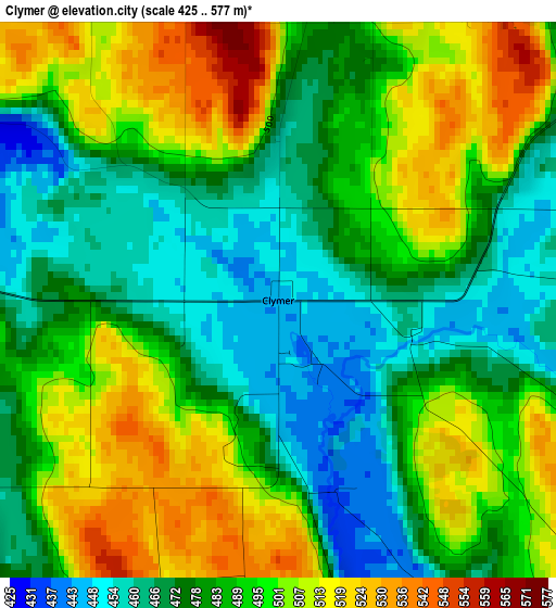
Below is the Elevation map of Clymer, which displays elevation range with different colors. Scale of the first map is from 425 to 577 m (1394 to 1893 ft) with average elevation of 487.5 meters (=1599 ft) [note 1]
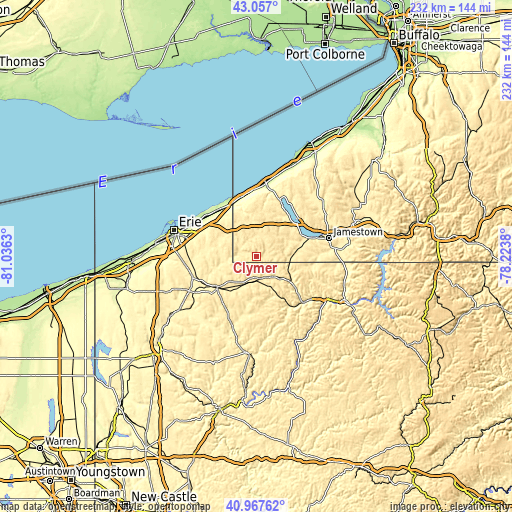
These maps also provides idea of topography and contour of this city, they are displayed at different zoom levels. More info about maps, scale and edge coordinates you can find below images.
| \ | Map #1 | Topo.Map |
| Scale [m] | 425..577 m | × |
| Scale [ft] | 1394..1893 ft | × |
| Average | 487.5 m = 1599 ft | × |
| Width | 7.26 km = 4.5 mi | 232.3 km = 144.3 mi |
| Height | 7.26 km = 4.5 mi | 232.3 km = 144.3 mi |
| ↑Max Latitude | 42.053529° | 43.057° |
| Latitude at center | 42.02089° | 42.02089° |
| ↓Min Latitude | 41.988235° | 40.96762° |
| ← Min Longitude | -79.673995° | -81.0363° |
| Longitude center | -79.63005° | -79.63005° |
| →Max Longitude | -79.586105° | -78.2238° |
Nearby cities:
Cities around Clymer sort by population:
• Jamestown elevation 420 m
33.7 km,  75°
75°
• Northwest Harborcreek 221 m
33.3 km,  295°
295°
• Corry 437 m
11.2 km,  184°
184°
• North East 244 m
27.4 km,  322°
322°
• Union City 386 m
22.3 km,  232°
232°
• Westfield 230 m
33.8 km,  7°
7°
• Lakewood 409 m
26.2 km,  69°
69°
• Jamestown West 458 m
29.8 km, 75°
• Mayville 444 m
27.9 km,  21°
21°
• Youngsville 366 m
31.9 km,  126°
126°
• Waterford 372 m
30.6 km,  253°
253°
• Celoron 407 m
30.3 km, 71°
Multilingual:
 En español:
Clymer elevación 444 m.
 En France:
Clymer élévation 444 m.


Sources and notes:
- [note 1] Map square and city borders are not equal. Map elevation data is calculated only from area inside that square.
- [src 1] Elevation data from geonames database provided with same terms of usage.
- [src 2] The elevation map of Clymer is generated using elevation data from NASA's 3 arcsec (90m) resolution SRTM data.
- [src 3] Base (background) map © OpenStreetMap contributors tiles are generated by Geofabrik and OpenTopoMap.
Copyright & License:
This Clymer Elevation Map is licensed under CC BY-SA. You may reuse any part from this page, if you give a proper credit by linking to this URL:
 More info on terms of use page.