Ambridge elevation
Ambridge (Pennsylvania, Beaver County), United States elevation is 237 meters and Ambridge elevation in feet is 778 ft above sea level [src 1]. Ambridge is a populated place (feature code) with elevation that is 42 meters (138 ft) smaller than average city elevation in United States.
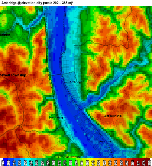
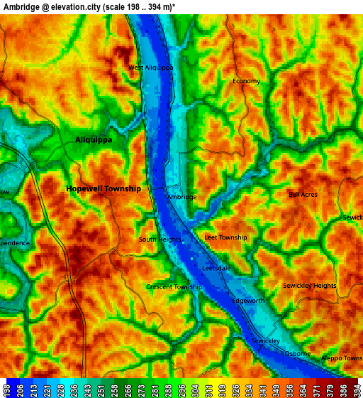
Below is the Elevation map of Ambridge, which displays elevation range with different colors. Scale of the first map is from 202 to 385 m (663 to 1263 ft) with average elevation of 290.9 meters (=954 ft) [note 1]
These maps also provides idea of topography and contour of this city, they are displayed at different zoom levels. More info about maps, scale and edge coordinates you can find below images.
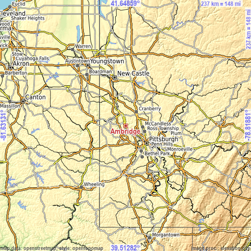
| \ | Map #1 | Map #2 | Topo.Map |
| Scale [m] | 202..385 m | 198..394 m | × |
| Scale [ft] | 663..1263 ft | 650..1293 ft | × |
| Average | 290.9 m = 954 ft | 307.2 m = 1008 ft | × |
| Width | 7.42 km = 4.6 mi | 14.84 km = 9.2 mi | 237.5 km = 147.6 mi |
| Height | 7.42 km = 4.6 mi | 14.84 km = 9.2 mi | 237.5 km = 147.6 mi |
| ↑Max Latitude | 40.622593° | 40.65594° | 41.64859° |
| Latitude at center | 40.58923° | 40.58923° | 40.58923° |
| ↓Min Latitude | 40.55585° | 40.522453° | 39.51282° |
| ← Min Longitude | -80.269005° | -80.312951° | -81.63131° |
| Longitude center | -80.22506° | -80.22506° | -80.22506° |
| →Max Longitude | -80.181115° | -80.137169° | -78.81881° |
Nearby cities:
Cities around Ambridge sort by population:
• Franklin Park elevation 376 m
11.6 km,  93°
93°
• Carnot-Moon 346 m
7.9 km,  175°
175°
• Economy 242 m
1.2 km,  1°
1°
• Aliquippa 225 m
5.4 km,  346°
346°
• Coraopolis 220 m
9.3 km,  147°
147°
• Baden 237 m
5.1 km,  357°
357°
• Sewickley 228 m
6.8 km, 149°
• Conway 226 m
7.9 km, 351°
• Edgeworth 221 m
5 km, 147°
• Freedom 237 m
11 km, 348°
• Bell Acres 364 m
4.9 km, 88°
• Leetsdale 217 m
3.2 km, 154°
Multilingual:
 En español:
Ambridge elevación 237 m.
 En France:
Ambridge élévation 237 m.
 Auf Deutsch:
Ambridge höhe über dem Meeresspiegel ist 237 m.

Sources and notes:
- [note 1] Map square and city borders are not equal. Map elevation data is calculated only from area inside that square.
- [src 1] Elevation data from geonames database provided with same terms of usage.
- [src 2] The elevation map of Ambridge is generated using elevation data from NASA's 3 arcsec (90m) resolution SRTM data.
- [src 3] Base (background) map © OpenStreetMap contributors tiles are generated by Geofabrik and OpenTopoMap.
Copyright & License:
This Ambridge Elevation Map is licensed under CC BY-SA. You may reuse any part from this page, if you give a proper credit by linking to this URL:
 More info on terms of use page.