Perry Heights elevation
Perry Heights (Ohio, Stark County), United States elevation is 335 meters and Perry Heights elevation in feet is 1099 ft above sea level [src 1]. Perry Heights is a populated place (feature code) with elevation that is 56 meters (184 ft) bigger than average city elevation in United States.
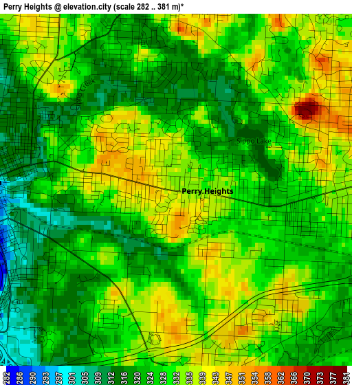
Below is the Elevation map of Perry Heights, which displays elevation range with different colors. Scale of the first map is from 282 to 381 m (925 to 1250 ft) with average elevation of 327.6 meters (=1075 ft) [note 1]
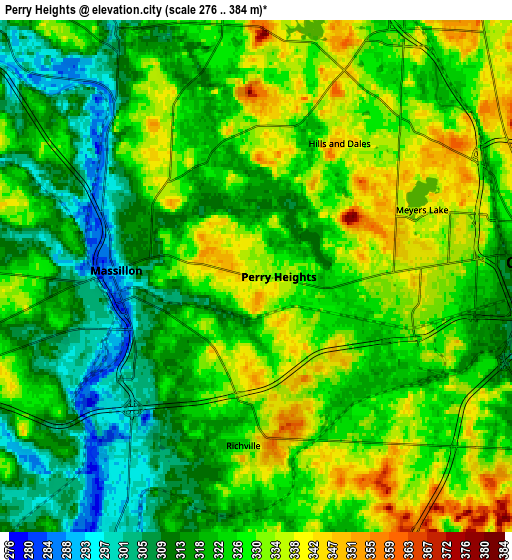
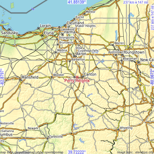
These maps also provides idea of topography and contour of this city, they are displayed at different zoom levels. More info about maps, scale and edge coordinates you can find below images.
| \ | Map #1 | Map #2 | Topo.Map |
| Scale [m] | 282..381 m | 276..384 m | × |
| Scale [ft] | 925..1250 ft | 906..1260 ft | × |
| Average | 327.6 m = 1075 ft | 324 m = 1063 ft | × |
| Width | 7.4 km = 4.6 mi | 14.8 km = 9.2 mi | 236.7 km = 147.1 mi |
| Height | 7.4 km = 4.6 mi | 14.8 km = 9.2 mi | 236.7 km = 147.1 mi |
| ↑Max Latitude | 40.8286° | 40.861844° | 41.85139° |
| Latitude at center | 40.79534° | 40.79534° | 40.79534° |
| ↓Min Latitude | 40.762063° | 40.728769° | 39.72222° |
| ← Min Longitude | -81.517395° | -81.561341° | -82.8797° |
| Longitude center | -81.47345° | -81.47345° | -81.47345° |
| →Max Longitude | -81.429505° | -81.385559° | -80.0672° |
Nearby cities:
Cities around Perry Heights sort by population:
• Canton elevation 329 m
8 km,  87°
87°
• Massillon 292 m
4 km,  272°
272°
• Green 351 m
16.8 km,  357°
357°
• North Canton 352 m
10.8 km,  33°
33°
• Canal Fulton 292 m
14.8 km,  315°
315°
• Greentown 366 m
15.9 km,  22°
22°
• Richville 324 m
4.9 km,  184°
184°
• Greensburg 359 m
15.2 km,  2°
2°
• Genoa 349 m
1.5 km,  157°
157°
• Brewster 303 m
14.4 km,  226°
226°
• Navarre 295 m
8.9 km,  207°
207°
• East Canton 357 m
16.1 km, 93°
Multilingual:
 En español:
Perry Heights elevación 335 m.
 En France:
Perry Heights élévation 335 m.
 Auf Deutsch:
Perry Heights höhe über dem Meeresspiegel ist 335 m.

Sources and notes:
- [note 1] Map square and city borders are not equal. Map elevation data is calculated only from area inside that square.
- [src 1] Elevation data from geonames database provided with same terms of usage.
- [src 2] The elevation map of Perry Heights is generated using elevation data from NASA's 3 arcsec (90m) resolution SRTM data.
- [src 3] Base (background) map © OpenStreetMap contributors tiles are generated by Geofabrik and OpenTopoMap.
Copyright & License:
This Perry Heights Elevation Map is licensed under CC BY-SA. You may reuse any part from this page, if you give a proper credit by linking to this URL:
 More info on terms of use page.