Ashland elevation
Ashland (Ohio, Ashland County), United States elevation is 325 meters and Ashland elevation in feet is 1066 ft above sea level [src 1]. Ashland is a seat of a second-order administrative division (feature code) with elevation that is 46 meters (151 ft) bigger than average city elevation in United States.
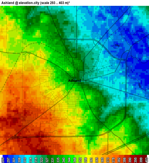
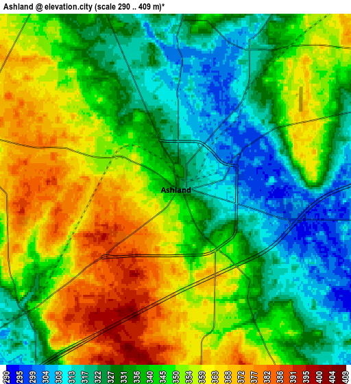
Below is the Elevation map of Ashland, which displays elevation range with different colors. Scale of the first map is from 293 to 403 m (961 to 1322 ft) with average elevation of 340.7 meters (=1118 ft) [note 1]
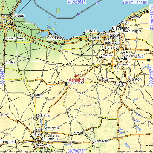
These maps also provides idea of topography and contour of this city, they are displayed at different zoom levels. More info about maps, scale and edge coordinates you can find below images.
| \ | Map #1 | Map #2 | Topo.Map |
| Scale [m] | 293..403 m | 290..409 m | × |
| Scale [ft] | 961..1322 ft | 951..1342 ft | × |
| Average | 340.7 m = 1118 ft | 342.7 m = 1124 ft | × |
| Width | 7.39 km = 4.6 mi | 14.78 km = 9.2 mi | 236.5 km = 147 mi |
| Height | 7.39 km = 4.6 mi | 14.78 km = 9.2 mi | 236.5 km = 147 mi |
| ↑Max Latitude | 40.901894° | 40.935101° | 41.92354° |
| Latitude at center | 40.86867° | 40.86867° | 40.86867° |
| ↓Min Latitude | 40.83543° | 40.802173° | 39.79673° |
| ← Min Longitude | -82.362165° | -82.406111° | -83.72447° |
| Longitude center | -82.31822° | -82.31822° | -82.31822° |
| →Max Longitude | -82.274275° | -82.230329° | -80.91197° |
Nearby cities:
Cities around Ashland sort by population:
• Mansfield elevation 382 m
20.6 km,  233°
233°
• Shelby 333 m
28.9 km,  272°
272°
• Ontario 413 m
25.9 km,  242°
242°
• Lexington 371 m
30.7 km, 226°
• Lincoln Heights 398 m
17.7 km, 232°
• Lodi 282 m
31.6 km,  54°
54°
• Loudonville 297 m
26.9 km,  164°
164°
• New London 299 m
25 km,  344°
344°
• Bellville 348 m
32 km,  210°
210°
• Shreve 274 m
32.5 km,  129°
129°
• West Salem 339 m
20.9 km,  56°
56°
• Greenwich 312 m
24.4 km,  317°
317°
Multilingual:
 En español:
Ashland elevación 325 m.
 En France:
Ashland élévation 325 m.


Sources and notes:
- [note 1] Map square and city borders are not equal. Map elevation data is calculated only from area inside that square.
- [src 1] Elevation data from geonames database provided with same terms of usage.
- [src 2] The elevation map of Ashland is generated using elevation data from NASA's 3 arcsec (90m) resolution SRTM data.
- [src 3] Base (background) map © OpenStreetMap contributors tiles are generated by Geofabrik and OpenTopoMap.
Copyright & License:
This Ashland Elevation Map is licensed under CC BY-SA. You may reuse any part from this page, if you give a proper credit by linking to this URL:
 More info on terms of use page.