Yorkshire elevation
Yorkshire (New York, Cattaraugus County), United States elevation is 440 meters and Yorkshire elevation in feet is 1444 ft above sea level [src 1]. Yorkshire is a populated place (feature code) with elevation that is 161 meters (528 ft) bigger than average city elevation in United States.
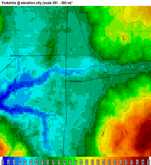
Below is the Elevation map of Yorkshire, which displays elevation range with different colors. Scale of the first map is from 391 to 583 m (1283 to 1913 ft) with average elevation of 456.8 meters (=1499 ft) [note 1]
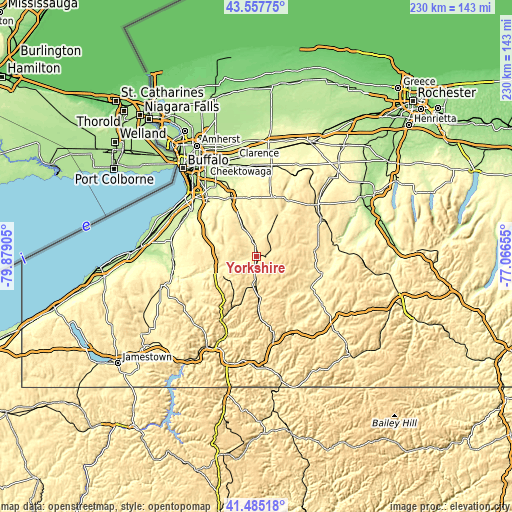
These maps also provides idea of topography and contour of this city, they are displayed at different zoom levels. More info about maps, scale and edge coordinates you can find below images.
| \ | Map #1 | Topo.Map |
| Scale [m] | 391..583 m | × |
| Scale [ft] | 1283..1913 ft | × |
| Average | 456.8 m = 1499 ft | × |
| Width | 7.2 km = 4.5 mi | 230.4 km = 143.2 mi |
| Height | 7.2 km = 4.5 mi | 230.4 km = 143.2 mi |
| ↑Max Latitude | 42.562436° | 43.55775° |
| Latitude at center | 42.53006° | 42.53006° |
| ↓Min Latitude | 42.497667° | 41.48518° |
| ← Min Longitude | -78.516745° | -79.87905° |
| Longitude center | -78.4728° | -78.4728° |
| →Max Longitude | -78.428855° | -77.06655° |
Nearby cities:
Cities around Yorkshire sort by population:
• Hamburg elevation 252 m
35.8 km,  305°
305°
• Boston 289 m
24.3 km,  296°
296°
• East Aurora 281 m
28.8 km,  336°
336°
• Springville 408 m
16.1 km,  261°
261°
• Orchard Park 265 m
34.5 km,  319°
319°
• North Boston 252 m
30.3 km, 304°
• Arcade 452 m
4.1 km,  83°
83°
• Houghton 371 m
28.5 km,  114°
114°
• Billington Heights 297 m
30.9 km, 336°
• Franklinville 487 m
21.5 km,  176°
176°
• Holland 339 m
13.6 km, 335°
• Delevan 436 m
4.6 km,  188°
188°
Multilingual:
 En español:
Yorkshire elevación 440 m.
 En France:
Yorkshire élévation 440 m.
 Auf Deutsch:
Yorkshire höhe über dem Meeresspiegel ist 440 m.

Sources and notes:
- [note 1] Map square and city borders are not equal. Map elevation data is calculated only from area inside that square.
- [src 1] Elevation data from geonames database provided with same terms of usage.
- [src 2] The elevation map of Yorkshire is generated using elevation data from NASA's 3 arcsec (90m) resolution SRTM data.
- [src 3] Base (background) map © OpenStreetMap contributors tiles are generated by Geofabrik and OpenTopoMap.
Copyright & License:
This Yorkshire Elevation Map is licensed under CC BY-SA. You may reuse any part from this page, if you give a proper credit by linking to this URL:
 More info on terms of use page.