Boston elevation
Boston (New York, Erie County), United States elevation is 289 meters and Boston elevation in feet is 948 ft above sea level [src 1]. Boston is a populated place (feature code) with elevation that is 10 meters (33 ft) bigger than average city elevation in United States.
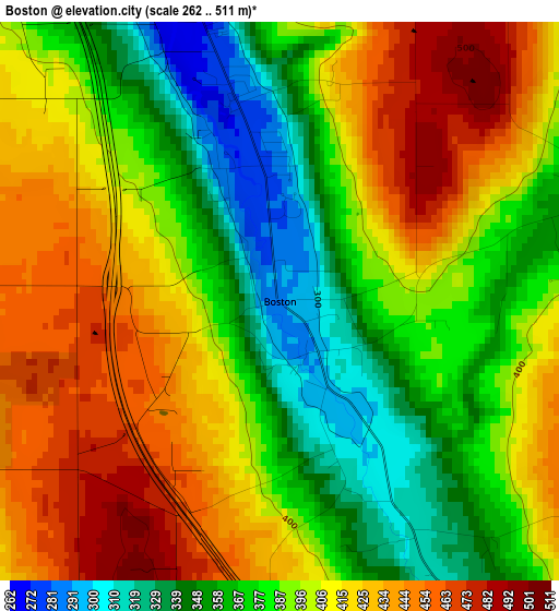
Below is the Elevation map of Boston, which displays elevation range with different colors. Scale of the first map is from 262 to 511 m (860 to 1677 ft) with average elevation of 396.4 meters (=1301 ft) [note 1]
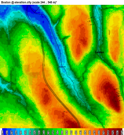
These maps also provides idea of topography and contour of this city, they are displayed at different zoom levels. More info about maps, scale and edge coordinates you can find below images.
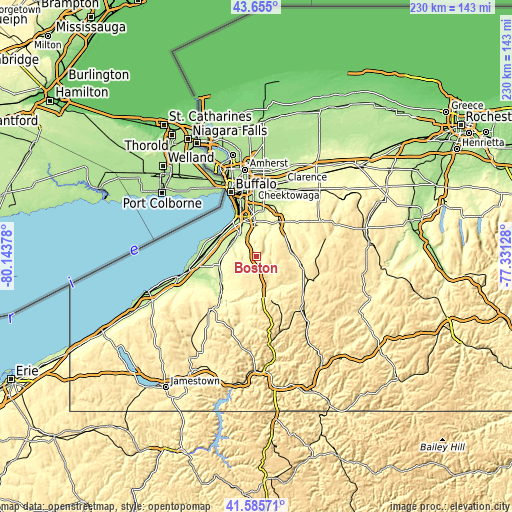
| \ | Map #1 | Map #2 | Topo.Map |
| Scale [m] | 262..511 m | 244..548 m | × |
| Scale [ft] | 860..1677 ft | 801..1798 ft | × |
| Average | 396.4 m = 1301 ft | 397.6 m = 1304 ft | × |
| Width | 7.19 km = 4.5 mi | 14.38 km = 8.9 mi | 230.1 km = 143 mi |
| Height | 7.19 km = 4.5 mi | 14.38 km = 8.9 mi | 230.1 km = 143 mi |
| ↑Max Latitude | 42.661275° | 42.693582° | 43.655° |
| Latitude at center | 42.62895° | 42.62895° | 42.62895° |
| ↓Min Latitude | 42.596609° | 42.56425° | 41.58571° |
| ← Min Longitude | -78.781475° | -78.825421° | -80.14378° |
| Longitude center | -78.73753° | -78.73753° | -78.73753° |
| →Max Longitude | -78.693585° | -78.649639° | -77.33128° |
Nearby cities:
Cities around Boston sort by population:
• Lackawanna elevation 191 m
23 km,  342°
342°
• Hamburg 252 m
12.2 km,  322°
322°
• East Aurora 281 m
18.5 km,  33°
33°
• Springville 408 m
14.6 km,  156°
156°
• Eden 251 m
13.3 km,  281°
281°
• Orchard Park 265 m
15.4 km,  358°
358°
• Wanakah 185 m
18.8 km,  313°
313°
• Blasdell 188 m
20 km, 339°
• North Boston 252 m
7.1 km,  333°
333°
• Billington Heights 297 m
19.5 km, 27°
• North Collins 253 m
17.1 km,  257°
257°
• Holland 339 m
16.1 km,  85°
85°
Multilingual:
 En español:
Boston elevación 289 m.
 En France:
Boston élévation 289 m.


Sources and notes:
- [note 1] Map square and city borders are not equal. Map elevation data is calculated only from area inside that square.
- [src 1] Elevation data from geonames database provided with same terms of usage.
- [src 2] The elevation map of Boston is generated using elevation data from NASA's 3 arcsec (90m) resolution SRTM data.
- [src 3] Base (background) map © OpenStreetMap contributors tiles are generated by Geofabrik and OpenTopoMap.
Copyright & License:
This Boston Elevation Map is licensed under CC BY-SA. You may reuse any part from this page, if you give a proper credit by linking to this URL:
 More info on terms of use page.