Whitehall elevation
Whitehall (New York, Washington County), United States elevation is 45 meters and Whitehall elevation in feet is 148 ft above sea level [src 1]. Whitehall is a populated place (feature code) with elevation that is 234 meters (768 ft) smaller than average city elevation in United States.
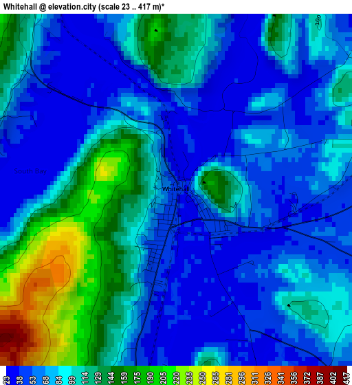
Below is the Elevation map of Whitehall, which displays elevation range with different colors. Scale of the first map is from 23 to 417 m (75 to 1368 ft) with average elevation of 90.2 meters (=296 ft) [note 1]
These maps also provides idea of topography and contour of this city, they are displayed at different zoom levels. More info about maps, scale and edge coordinates you can find below images.
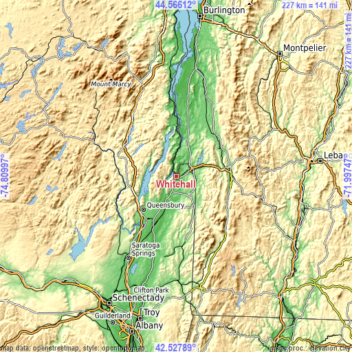
| \ | Map #1 | Topo.Map |
| Scale [m] | 23..417 m | × |
| Scale [ft] | 75..1368 ft | × |
| Average | 90.2 m = 296 ft | × |
| Width | 7.08 km = 4.4 mi | 226.6 km = 140.8 mi |
| Height | 7.08 km = 4.4 mi | 226.6 km = 140.8 mi |
| ↑Max Latitude | 43.587459° | 44.56612° |
| Latitude at center | 43.55562° | 43.55562° |
| ↓Min Latitude | 43.523764° | 42.52789° |
| ← Min Longitude | -73.447665° | -74.80997° |
| Longitude center | -73.40372° | -73.40372° |
| →Max Longitude | -73.359775° | -71.99747° |
Nearby cities:
Cities around Whitehall sort by population:
• Queensbury elevation 101 m
26.1 km,  220°
220°
• Glens Falls North 143 m
33.3 km, 222°
• Hudson Falls 93 m
31.9 km,  207°
207°
• Ticonderoga 51 m
32.6 km,  357°
357°
• Warrensburg 230 m
30.7 km,  257°
257°
• Granville 129 m
20.1 km,  144°
144°
• Fair Haven 119 m
11.9 km,  68°
68°
• Hartford 118 m
21.4 km,  177°
177°
• West Rutland 153 m
29.2 km,  81°
81°
• Poultney 131 m
14.2 km,  107°
107°
• Castleton 139 m
19 km, 71°
• Pawlet 219 m
29.6 km, 141°
Multilingual:
 En español:
Whitehall elevación 45 m.
 En France:
Whitehall élévation 45 m.
 Auf Deutsch:
Whitehall höhe über dem Meeresspiegel ist 45 m.

Sources and notes:
- [note 1] Map square and city borders are not equal. Map elevation data is calculated only from area inside that square.
- [src 1] Elevation data from geonames database provided with same terms of usage.
- [src 2] The elevation map of Whitehall is generated using elevation data from NASA's 3 arcsec (90m) resolution SRTM data.
- [src 3] Base (background) map © OpenStreetMap contributors tiles are generated by Geofabrik and OpenTopoMap.
Copyright & License:
This Whitehall Elevation Map is licensed under CC BY-SA. You may reuse any part from this page, if you give a proper credit by linking to this URL:
 More info on terms of use page.