Trumansburg elevation
Trumansburg (New York, Tompkins County), United States elevation is 303 meters and Trumansburg elevation in feet is 994 ft above sea level [src 1]. Trumansburg is a populated place (feature code) with elevation that is 24 meters (79 ft) bigger than average city elevation in United States.
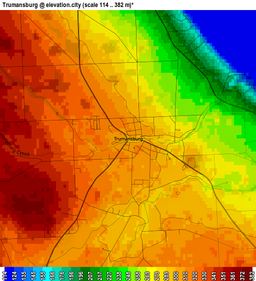
Below is the Elevation map of Trumansburg, which displays elevation range with different colors. Scale of the first map is from 114 to 382 m (374 to 1253 ft) with average elevation of 289.6 meters (=950 ft) [note 1]
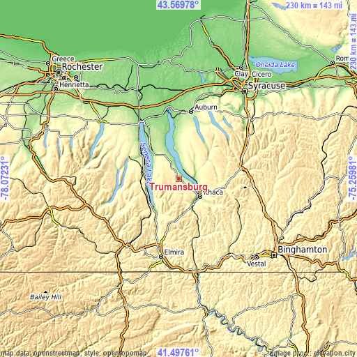
These maps also provides idea of topography and contour of this city, they are displayed at different zoom levels. More info about maps, scale and edge coordinates you can find below images.
| \ | Map #1 | Topo.Map |
| Scale [m] | 114..382 m | × |
| Scale [ft] | 374..1253 ft | × |
| Average | 289.6 m = 950 ft | × |
| Width | 7.2 km = 4.5 mi | 230.4 km = 143.2 mi |
| Height | 7.2 km = 4.5 mi | 230.4 km = 143.2 mi |
| ↑Max Latitude | 42.57466° | 43.56978° |
| Latitude at center | 42.54229° | 42.54229° |
| ↓Min Latitude | 42.509904° | 41.49761° |
| ← Min Longitude | -76.710005° | -78.07231° |
| Longitude center | -76.66606° | -76.66606° |
| →Max Longitude | -76.622115° | -75.25981° |
Nearby cities:
Cities around Trumansburg sort by population:
• Ithaca elevation 127 m
17.9 km,  129°
129°
• South Hill 238 m
18.8 km, 131°
• Cayuga Heights 249 m
17.2 km,  122°
122°
• Lansing 285 m
16.6 km,  112°
112°
• Northeast Ithaca 318 m
18.5 km, 115°
• Groton 307 m
25 km,  78°
78°
• East Ithaca 250 m
19.2 km, 126°
• Watkins Glen 139 m
24.7 km,  223°
223°
• Montour Falls 141 m
26.2 km,  214°
214°
• Dundee 302 m
25.5 km,  265°
265°
• Northwest Ithaca 275 m
13 km, 127°
• Moravia 227 m
27.5 km,  46°
46°
Multilingual:
 En español:
Trumansburg elevación 303 m.
 En France:
Trumansburg élévation 303 m.
 Auf Deutsch:
Trumansburg höhe über dem Meeresspiegel ist 303 m.

Sources and notes:
- [note 1] Map square and city borders are not equal. Map elevation data is calculated only from area inside that square.
- [src 1] Elevation data from geonames database provided with same terms of usage.
- [src 2] The elevation map of Trumansburg is generated using elevation data from NASA's 3 arcsec (90m) resolution SRTM data.
- [src 3] Base (background) map © OpenStreetMap contributors tiles are generated by Geofabrik and OpenTopoMap.
Copyright & License:
This Trumansburg Elevation Map is licensed under CC BY-SA. You may reuse any part from this page, if you give a proper credit by linking to this URL:
 More info on terms of use page.