Groton elevation
Groton (New York, Tompkins County), United States elevation is 307 meters and Groton elevation in feet is 1007 ft above sea level [src 1]. Groton is a populated place (feature code) with elevation that is 28 meters (92 ft) bigger than average city elevation in United States.
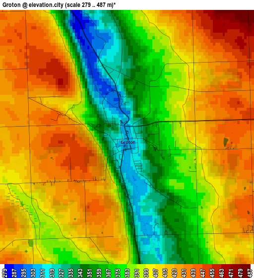
Below is the Elevation map of Groton, which displays elevation range with different colors. Scale of the first map is from 279 to 487 m (915 to 1598 ft) with average elevation of 397.1 meters (=1303 ft) [note 1]
These maps also provides idea of topography and contour of this city, they are displayed at different zoom levels. More info about maps, scale and edge coordinates you can find below images.
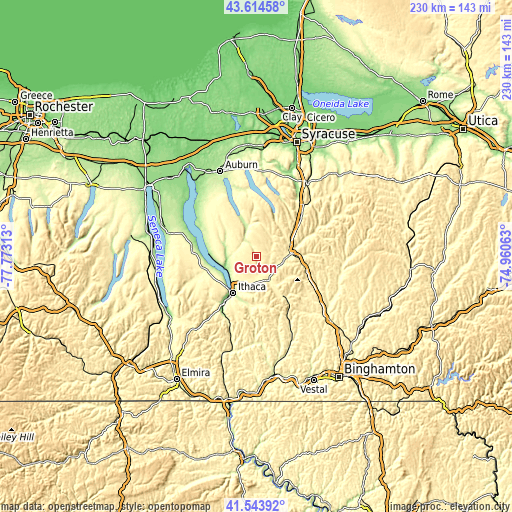
| \ | Map #1 | Topo.Map |
| Scale [m] | 279..487 m | × |
| Scale [ft] | 915..1598 ft | × |
| Average | 397.1 m = 1303 ft | × |
| Width | 7.19 km = 4.5 mi | 230.2 km = 143 mi |
| Height | 7.19 km = 4.5 mi | 230.2 km = 143 mi |
| ↑Max Latitude | 42.620196° | 43.61458° |
| Latitude at center | 42.58785° | 42.58785° |
| ↓Min Latitude | 42.555487° | 41.54392° |
| ← Min Longitude | -76.410825° | -77.77313° |
| Longitude center | -76.36688° | -76.36688° |
| →Max Longitude | -76.322935° | -74.96063° |
Nearby cities:
Cities around Groton sort by population:
• Ithaca elevation 127 m
19.5 km,  213°
213°
• Cortland 343 m
15.3 km,  84°
84°
• Cayuga Heights 249 m
17.3 km, 214°
• Lansing 285 m
14.8 km,  218°
218°
• Homer 345 m
16.3 km,  70°
70°
• Munsons Corners 360 m
12.9 km,  92°
92°
• Northeast Ithaca 318 m
15.2 km, 210°
• East Ithaca 250 m
18.9 km, 209°
• Dryden 334 m
12.2 km,  152°
152°
• Northwest Ithaca 275 m
19.4 km,  227°
227°
• Cortland West 399 m
11.6 km, 86°
• Moravia 227 m
14.6 km,  342°
342°
Multilingual:
 En español:
Groton elevación 307 m.
 En France:
Groton élévation 307 m.


Sources and notes:
- [note 1] Map square and city borders are not equal. Map elevation data is calculated only from area inside that square.
- [src 1] Elevation data from geonames database provided with same terms of usage.
- [src 2] The elevation map of Groton is generated using elevation data from NASA's 3 arcsec (90m) resolution SRTM data.
- [src 3] Base (background) map © OpenStreetMap contributors tiles are generated by Geofabrik and OpenTopoMap.
Copyright & License:
This Groton Elevation Map is licensed under CC BY-SA. You may reuse any part from this page, if you give a proper credit by linking to this URL:
 More info on terms of use page.