Tappan elevation
Tappan (New York, Rockland County), United States elevation is 17 meters and Tappan elevation in feet is 56 ft above sea level [src 1]. Tappan is a populated place (feature code) with elevation that is 262 meters (860 ft) smaller than average city elevation in United States.
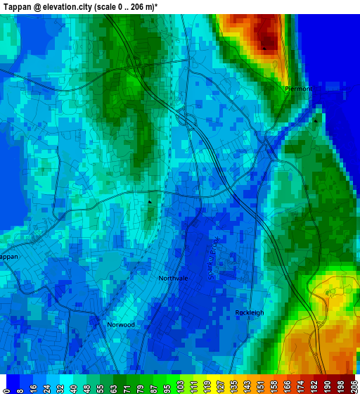
Below is the Elevation map of Tappan, which displays elevation range with different colors. Scale of the first map is from 0 to 206 m (0 to 676 ft) with average elevation of 41.7 meters (=137 ft) [note 1]
These maps also provides idea of topography and contour of this city, they are displayed at different zoom levels. More info about maps, scale and edge coordinates you can find below images.
| \ | Map #1 | Map #2 | Topo.Map |
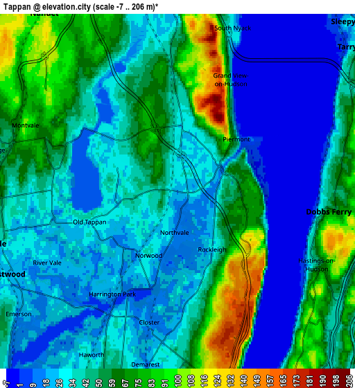
| Scale [m] | 0..206 m | -7..206 m | × |
| Scale [ft] | 0..676 ft | -23..676 ft | × |
| Average | 41.7 m = 137 ft | 43.3 m = 142 ft | × |
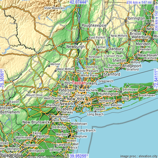
| Width | 7.37 km = 4.6 mi | 14.75 km = 9.2 mi | 235.9 km = 146.6 mi |
| Height | 7.37 km = 4.6 mi | 14.75 km = 9.2 mi | 235.9 km = 146.6 mi |
| ↑Max Latitude | 41.055187° | 41.088316° | 42.07444° |
| Latitude at center | 41.02204° | 41.02204° | 41.02204° |
| ↓Min Latitude | 40.988877° | 40.955697° | 39.95255° |
| ← Min Longitude | -73.991305° | -74.035251° | -75.35361° |
| Longitude center | -73.94736° | -73.94736° | -73.94736° |
| →Max Longitude | -73.903415° | -73.859469° | -72.54111° |
Nearby cities:
Cities around Tappan sort by population:
• Dobbs Ferry elevation 71 m
6.3 km,  97°
97°
• River Vale 22 m
6.2 km,  241°
241°
• Closter 15 m
5.6 km,  192°
192°
• Hastings-on-Hudson 50 m
6.5 km,  117°
117°
• Old Tappan 27 m
3.9 km,  251°
251°
• Norwood 36 m
2.9 km,  204°
204°
• Blauvelt 66 m
4.7 km,  349°
349°
• Northvale 16 m
1.7 km,  184°
184°
• Harrington Park 21 m
5.1 km,  212°
212°
• Orangeburg 38 m
2.7 km,  356°
356°
• Piermont 46 m
3.3 km,  47°
47°
• Sparkill 18 m
2 km,  59°
59°
Multilingual:
 En español:
Tappan elevación 17 m.
 En France:
Tappan élévation 17 m.


Sources and notes:
- [note 1] Map square and city borders are not equal. Map elevation data is calculated only from area inside that square.
- [src 1] Elevation data from geonames database provided with same terms of usage.
- [src 2] The elevation map of Tappan is generated using elevation data from NASA's 3 arcsec (90m) resolution SRTM data.
- [src 3] Base (background) map © OpenStreetMap contributors tiles are generated by Geofabrik and OpenTopoMap.
Copyright & License:
This Tappan Elevation Map is licensed under CC BY-SA. You may reuse any part from this page, if you give a proper credit by linking to this URL:
 More info on terms of use page.