Suffern elevation
Suffern (New York, Rockland County), United States elevation is 99 meters and Suffern elevation in feet is 325 ft above sea level [src 1]. Suffern is a populated place (feature code) with elevation that is 180 meters (591 ft) smaller than average city elevation in United States.
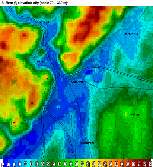
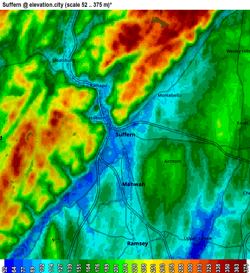
Below is the Elevation map of Suffern, which displays elevation range with different colors. Scale of the first map is from 70 to 330 m (230 to 1083 ft) with average elevation of 155.7 meters (=511 ft) [note 1]
These maps also provides idea of topography and contour of this city, they are displayed at different zoom levels. More info about maps, scale and edge coordinates you can find below images.
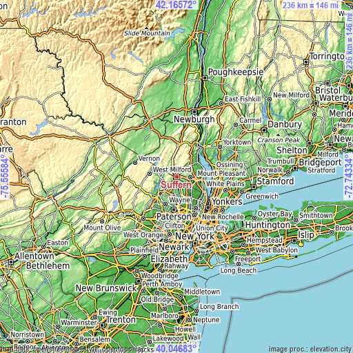
| \ | Map #1 | Map #2 | Topo.Map |
| Scale [m] | 70..330 m | 52..375 m | × |
| Scale [ft] | 230..1083 ft | 171..1230 ft | × |
| Average | 155.7 m = 511 ft | 176.1 m = 578 ft | × |
| Width | 7.36 km = 4.6 mi | 14.73 km = 9.2 mi | 235.6 km = 146.4 mi |
| Height | 7.36 km = 4.6 mi | 14.73 km = 9.2 mi | 235.6 km = 146.4 mi |
| ↑Max Latitude | 41.14792° | 41.181003° | 42.16572° |
| Latitude at center | 41.11482° | 41.11482° | 41.11482° |
| ↓Min Latitude | 41.081704° | 41.04857° | 40.04683° |
| ← Min Longitude | -74.193535° | -74.237481° | -75.55584° |
| Longitude center | -74.14959° | -74.14959° | -74.14959° |
| →Max Longitude | -74.105645° | -74.061699° | -72.74334° |
Nearby cities:
Cities around Suffern sort by population:
• Mahwah elevation 102 m
2.9 km,  170°
170°
• Monsey 167 m
6.8 km,  93°
93°
• Ramsey 106 m
6.4 km, 173°
• Ringwood 154 m
8 km,  268°
268°
• Airmont 183 m
3.2 km,  118°
118°
• Upper Saddle River 74 m
7.6 km,  145°
145°
• Viola 179 m
6.1 km,  66°
66°
• Allendale 114 m
8.3 km, 168°
• Wesley Hills 169 m
8.3 km,  53°
53°
• Kaser 174 m
6.9 km,  84°
84°
• Montebello 104 m
3.5 km, 47°
• Sloatsburg 106 m
5.7 km,  320°
320°
Multilingual:
 En español:
Suffern elevación 99 m.
 En France:
Suffern élévation 99 m.


Sources and notes:
- [note 1] Map square and city borders are not equal. Map elevation data is calculated only from area inside that square.
- [src 1] Elevation data from geonames database provided with same terms of usage.
- [src 2] The elevation map of Suffern is generated using elevation data from NASA's 3 arcsec (90m) resolution SRTM data.
- [src 3] Base (background) map © OpenStreetMap contributors tiles are generated by Geofabrik and OpenTopoMap.
Copyright & License:
This Suffern Elevation Map is licensed under CC BY-SA. You may reuse any part from this page, if you give a proper credit by linking to this URL:
 More info on terms of use page.