Port Jefferson elevation
Port Jefferson (New York, Suffolk County), United States elevation is 2 meters and Port Jefferson elevation in feet is 7 ft above sea level [src 1]. Port Jefferson is a populated place (feature code) with elevation that is 277 meters (909 ft) smaller than average city elevation in United States.
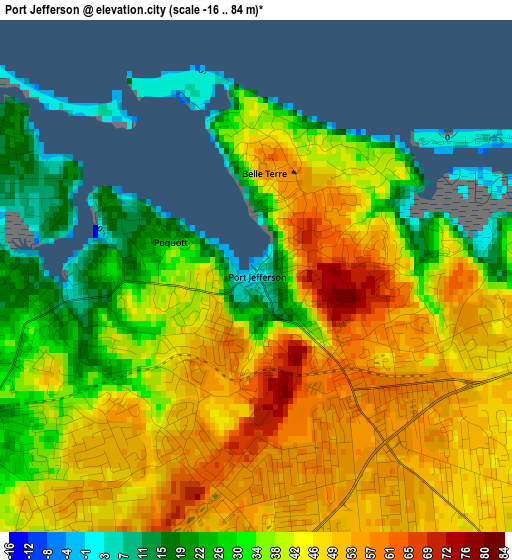
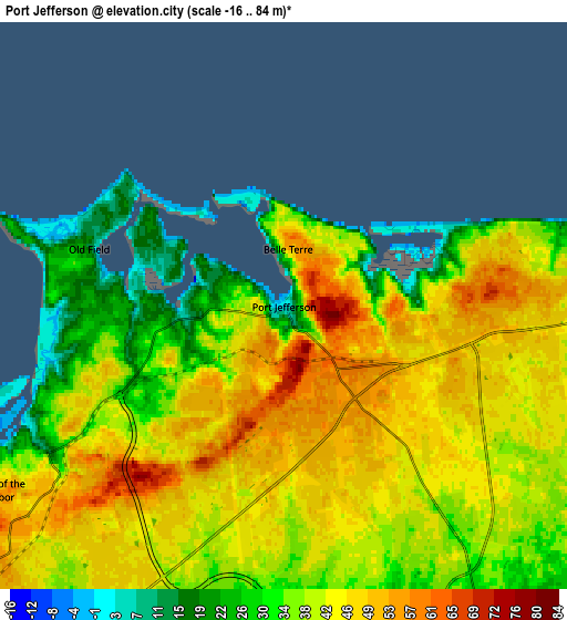
Below is the Elevation map of Port Jefferson, which displays elevation range with different colors. Scale of the first map is from -16 to 84 m (-52 to 276 ft) with average elevation of 41.1 meters (=135 ft) [note 1]
These maps also provides idea of topography and contour of this city, they are displayed at different zoom levels. More info about maps, scale and edge coordinates you can find below images.
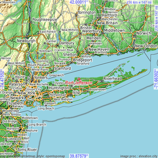
| \ | Map #1 | Map #2 | Topo.Map |
| Scale [m] | -16..84 m | -16..84 m | × |
| Scale [ft] | -52..276 ft | -52..276 ft | × |
| Average | 41.1 m = 135 ft | 40.1 m = 132 ft | × |
| Width | 7.38 km = 4.6 mi | 14.76 km = 9.2 mi | 236.2 km = 146.8 mi |
| Height | 7.38 km = 4.6 mi | 14.76 km = 9.2 mi | 236.2 km = 146.8 mi |
| ↑Max Latitude | 40.979675° | 41.012842° | 42.00011° |
| Latitude at center | 40.94649° | 40.94649° | 40.94649° |
| ↓Min Latitude | 40.913289° | 40.880071° | 39.87579° |
| ← Min Longitude | -73.113215° | -73.157161° | -74.47552° |
| Longitude center | -73.06927° | -73.06927° | -73.06927° |
| →Max Longitude | -73.025325° | -72.981379° | -71.66302° |
Nearby cities:
Cities around Port Jefferson sort by population:
• Coram elevation 30 m
10.4 km,  146°
146°
• Centereach 32 m
10.1 km,  194°
194°
• Selden 31 m
9.3 km,  162°
162°
• East Setauket 21 m
3.1 km,  259°
259°
• Setauket-East Setauket 34 m
3.3 km,  237°
237°
• Stony Brook 30 m
6.5 km,  248°
248°
• Miller Place 43 m
6.3 km,  76°
76°
• Mount Sinai 16 m
3.3 km,  88°
88°
• Terryville 47 m
4.2 km,  175°
175°
• Port Jefferson Station 54 m
3 km,  141°
141°
• Sound Beach 57 m
8.6 km, 82°
• Head of the Harbor 49 m
8.9 km, 237°
Multilingual:
 En español:
Port Jefferson elevación 2 m.
 En France:
Port Jefferson élévation 2 m.
 Auf Deutsch:
Port Jefferson höhe über dem Meeresspiegel ist 2 m.

Sources and notes:
- [note 1] Map square and city borders are not equal. Map elevation data is calculated only from area inside that square.
- [src 1] Elevation data from geonames database provided with same terms of usage.
- [src 2] The elevation map of Port Jefferson is generated using elevation data from NASA's 3 arcsec (90m) resolution SRTM data.
- [src 3] Base (background) map © OpenStreetMap contributors tiles are generated by Geofabrik and OpenTopoMap.
Copyright & License:
This Port Jefferson Elevation Map is licensed under CC BY-SA. You may reuse any part from this page, if you give a proper credit by linking to this URL:
 More info on terms of use page.