Monticello elevation
Monticello (New York, Sullivan County), United States elevation is 462 meters and Monticello elevation in feet is 1516 ft above sea level [src 1]. Monticello is a seat of a second-order administrative division (feature code) with elevation that is 183 meters (600 ft) bigger than average city elevation in United States.
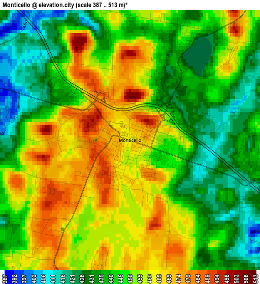
Below is the Elevation map of Monticello, which displays elevation range with different colors. Scale of the first map is from 387 to 513 m (1270 to 1683 ft) with average elevation of 448.4 meters (=1471 ft) [note 1]
These maps also provides idea of topography and contour of this city, they are displayed at different zoom levels. More info about maps, scale and edge coordinates you can find below images.
| \ | Map #1 | Map #2 | Topo.Map |
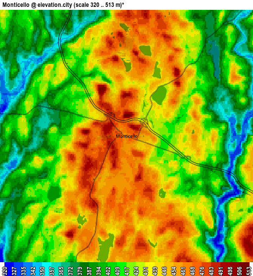
| Scale [m] | 387..513 m | 320..513 m | × |
| Scale [ft] | 1270..1683 ft | 1050..1683 ft | × |
| Average | 448.4 m = 1471 ft | 422.8 m = 1387 ft | × |
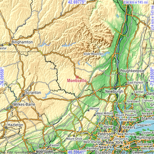
| Width | 7.3 km = 4.5 mi | 14.6 km = 9.1 mi | 233.6 km = 145.2 mi |
| Height | 7.3 km = 4.5 mi | 14.6 km = 9.1 mi | 233.6 km = 145.2 mi |
| ↑Max Latitude | 41.688475° | 41.721284° | 42.69775° |
| Latitude at center | 41.65565° | 41.65565° | 41.65565° |
| ↓Min Latitude | 41.622808° | 41.589949° | 40.59641° |
| ← Min Longitude | -74.733275° | -74.777221° | -76.09558° |
| Longitude center | -74.68933° | -74.68933° | -74.68933° |
| →Max Longitude | -74.645385° | -74.601439° | -73.28308° |
Nearby cities:
Cities around Monticello sort by population:
• Wawarsing elevation 91 m
29.9 km,  67°
67°
• Fallsburg 367 m
11.2 km,  40°
40°
• Liberty 460 m
16.9 km,  343°
343°
• Ellenville 105 m
25.3 km, 74°
• South Fallsburg 394 m
8.5 km,  32°
32°
• Rock Hill 423 m
8.3 km,  113°
113°
• Washington Heights 212 m
30.7 km,  132°
132°
• Livingston Manor 436 m
29.5 km, 337°
• Napanoch 104 m
28.2 km, 69°
• Wurtsboro 177 m
19 km,  117°
117°
• Otisville 266 m
23.8 km,  148°
148°
• Brownville 261 m
30.2 km,  57°
57°
Multilingual:
 En español:
Monticello elevación 462 m.
 En France:
Monticello élévation 462 m.
 Auf Deutsch:
Monticello höhe über dem Meeresspiegel ist 462 m.

Sources and notes:
- [note 1] Map square and city borders are not equal. Map elevation data is calculated only from area inside that square.
- [src 1] Elevation data from geonames database provided with same terms of usage.
- [src 2] The elevation map of Monticello is generated using elevation data from NASA's 3 arcsec (90m) resolution SRTM data.
- [src 3] Base (background) map © OpenStreetMap contributors tiles are generated by Geofabrik and OpenTopoMap.
Copyright & License:
This Monticello Elevation Map is licensed under CC BY-SA. You may reuse any part from this page, if you give a proper credit by linking to this URL:
 More info on terms of use page.